 |
By David Kier
After the establishment of five missions along El Camino Real between 1774 and 1791, stretching from El Rosario to San Miguel, the Dominican padres sought to expand their efforts further into the mountains of Baja California. Their goal was to convert the Native populations living at higher elevations and to secure safer routes for travel to mainland Mexico. Plans were drawn up to construct three mountain missions, but ultimately, only two were realized: San Pedro Mártir and Santa Catarina.
Founding and Early Exploration
In May 1793, while stationed in Loreto, Lieutenant Governor José Joaquín de Arrillaga authorized an expedition to scout possible mission sites in the mountainous regions of northern Baja California. By January 1794, a location east of Mission Santo Domingo was selected. On April 27, 1794, the mission was officially established at a place locally known as Casilepe, situated at an elevation of 6,800 feet. This original site remained a mystery to modern researchers until 1991, when an expedition rediscovered it at a meadow now called La Grulla. Read more about that discovery.
Relocation and Building Efforts
The cold climate at such a high altitude soon became a significant challenge. After just three months, the mission was moved to a new site called Ajantequedo, identified by the Kilawa Indians. This location was seven miles south and more than 1,700 feet lower in elevation than the original site. The mission at Ajantequedo was constructed with defensive walls, resembling a fort. Water for farming was supplied by two springs, with aqueducts built to transport water over half a mile to the mission grounds.

Conflicts and Administration
In May 1796, a violent incident occurred, resulting in wounded soldiers and the deaths of several Indigenous individuals. Lieutenant Governor Arrillaga traveled from Loreto to San Vicente in June to investigate the situation. By August, he reported that some Indigenous people were “escaping” and there was a request for a new padre to be assigned to the mountain mission.
Growth and Decline
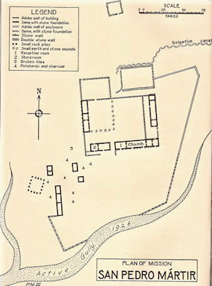
By 1800, the mission’s population had dwindled to just ninety-two people. The main agricultural product was corn, and cattle ranching proved to be especially successful. In 1801, an adobe church was constructed, measuring 17 by 69 feet, accompanied by a reception room (19 by 39 feet), two additional rooms (each 19 by 22 feet), and a storage area (19 by 33 feet). Despite these improvements, the mission soon entered a period of decline. Dominican records from this era are sparse, but an 1808 report stated that San Pedro Mártir, like Santa Catalina, was unable to sustain itself financially.
Abandonment and Remnants
Records after 1808 are scarce or nonexistent. According to one research paper, the mission was abandoned during a particularly cold winter in 1811, and the remaining inhabitants were relocated to Mission Santo Domingo.
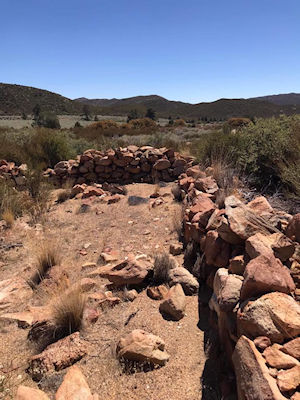
Today, all that remains of San Pedro Mártir are stone walls, tiles, and traces of adobe foundations. The mission site is accessible only on foot or horseback, with trips typically organized from Rancho Meling.
Related Sites: Visita de San Isidoro
One of San Pedro Mártir’s satellite sites was San Isidoro, which can now be reached by four-wheel-drive vehicles traveling east from the San Quintín valley. As of 2016, standing adobe walls at this visita were documented in a photograph taken by Tom Wimberly. Read more about San Isidoro, during Junípero Serra’s 1769 expedition to San Diego. See San Isidoro here.

Easy to obtain, good quality, auto insurance for Mexico.

Baja bound insurance is a professionally run organization. The staff communicates clearly and...

If you're looking for Mexican Insurance, then look no further. Baja Bound is hands down THE BEST...