 |
By David Kier
Traveling the mission road, El Camino Real, was no easy task. The shear rugged terrain, with rocks, cactus, and heat took its toll. If not for the natural springs and water pools, the journey would be impossible.
The Native Indians naturally knew where to find water and it was their trails and secrets that allowed the missionaries to expand their evangelical project across the peninsula’s harsh desert. Some of the better water sources became locations for missions and their visita satellite chapels. Others were waypoints along the network of trails we know as El Camino Real, the Royal Road or King’s Highway.
The Jesuits were the founders of seventeen California missions radiating across the peninsula from their first mission of Loreto. After San Ignacio’s Padre Fernando Consag (once again) proved California was not an island, during his 1746 coastal canoe expedition, his superiors began the push north in hopes of connecting with the mainland Mexico missions. Mission Santa Gertrudis was founded in 1752, Mission San Borja in 1762, and in 1766 a mission was founded at Calamajué.
For short periods, after rainfall, the little stream at Calamajué flowed potable water. This must have fooled the Jesuits during a recent expedition. Sadly, for them, the water returned to its normal salty state after the mission was established, and crops planted. The crops withered and died. A new location for their seventeenth mission was needed and a new name for a new beginning was applied. Just seven months after the founding at Calamajué, Mission Santa María was established, thirty miles to the northwest.
Two natural water sources are along El Camino Real between Calamajué and Santa María that we know today as San Francisquito and Las Palmitas. The first is located midway between the two mission sites, very close to the gold mills of Las Arrastras and since 2021 the new location of Coco’s Corner, along Mexico Highway 5.
Originally named San Francisco, from the diary of Junipero Serra, who stopped here on May 4, 1769. This was during his expedition to establish the missions in Alta California. Others mention the water source in the years that followed. Many old maps include it, as it was an important water source on El Camino Real. In the 1890s, the name was modified to San Francisquito. It really is a small place and so easy to miss.
While I have known about this watering place on El Camino Real from reading books and maps nearly all my life, I had never bothered to see it for myself. That all changed recently when my friend, Dave Wilcher, invited me to return with him to Baja California for a quick trip of historic exploration. This was terrific as I had been ‘Jonesing’ to revisit some sites, plus see places I had not yet been to, including San Francisquito.
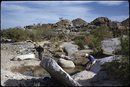
Photographs of the spring by Howard Gulick, in 1959, were a great inspiration and made it look really exotic with big boulders surrounding the pools of water. Gulick was the road log author and mapmaker for the very popular Lower California Guidebook, plus his unpublished paper on the El Camino Real made the location of San Francisquito easy to see. It is located less than a kilometer from Las Arrastras, where Coco moved his Corner to, in 2021. Read about Las Arrastras here.
Turn onto a short road to the west of Mexico Highway #5, just south of a small bridge, about Km. 178.5. Park and walk south in the arroyo. On Google Earth, you can see a small pond by the highway bridge dating back to construction days. The water table is pretty shallow, and water is needed to build paved roads. We didn’t care to see that pond. We were seeking a more natural one like what Gulick photographed 66 years earlier.
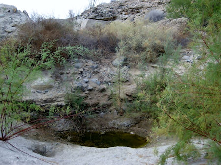
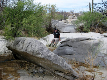
Dave and I went about exploring and probably walked right past the boulder seen in the 1959 photo. I continued south and did find a water: San Francisquito 2025. I was pretty happy about that and being pretty worn out, it was good enough for me. However, Dave was not satisfied. With a copy of Gulick’s photo in hand, he went back into the arroyo to search again.
Eureka! Dave found the boulder and was so enthusiastic that I had to muster up enough strength to walk back down the arroyo to where he was. No pool of water was there, as seen in 1959. Flash floods and wind move the sand, fill holes, and make new depressions down to the water table. Coyotes also can smell water and dig down to it. These are known as coyote wells.
View additional details, maps, and more here.
In the following months, I hope to share more Baja Travel Adventures from this 2025 expedition!


