|
By David Kier
In 1769, Padre Junípero Serra founded the first California Franciscan mission, at the Native ranchería of Velicatá. History here goes back even further.
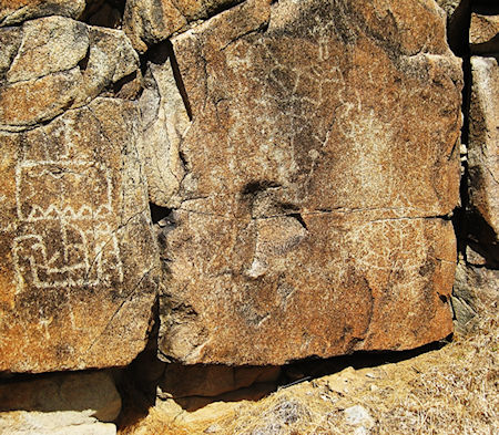
Petroglyphs on a cliff, one kilometer west of the mission church, date back between 500 and 1,000 years. One of the carvings resembles a Viking ship, inspiring TV’s Scott Wolter of America Unearthed to see it for himself. Read more.
The first missionary to find Velicatá was the Jesuit Padre Wenceslaus Linck during his 1766 expedition north from San Borja. He was seeking mission sites and to secure a corridor to the Colorado River for a safe land route to Mainland Mexico. Crossing the Gulf of California was still a very hazardous means of communication. Numerous individuals and significant shipments of cargo never reached Baja California’s shore.
Velicatá was to become a mission! However, the distance from San Borja was deemed too great in a potentially hostile region. An intermediate mission was established at Calamajué in October 1766. In May 1767, that mission was moved. This was because of Arroyo Calamajué and its bad water which killed the crops. After the move, it was given the name Santa María de los Angeles. Before the Jesuits could move on to Velicatá and begin building their 18th mission, they were expelled from the New World. The Jesuits would be replaced by the Franciscans, who arrived in April 1768. These new padres would assume operations of the fourteen Jesuit missions still open and reopen San José del Cabo, which was closed twenty years earlier. The biggest difference between the two administrations was that the Spanish government would have civil control whereas the Jesuits had a special arrangement that gave them total management of the peninsula. Within a year, the Franciscans were given a new directive. Instead of a corridor to the mainland they were to go to the Pacific coast, north of the peninsula.
The expedition to Alta California began in 1769. Two groups, separated by a few weeks, traveled from Loreto to the northernmost mission, Santa María. When the first group found that Santa María was lacking pasturage for the animals to feed upon, they continued on to Velicatá. The second group was led by Franciscan president, Junípero Serra.
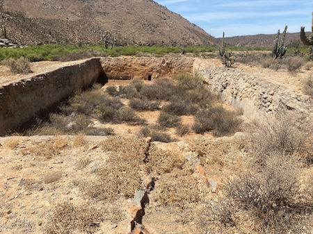
Serra found Santa María was in better shape than reports had said. He stayed there long enough to plan how to improve it. Serra directed a better Camino Real trail be made, as the deep canyon, prior to reaching the mission, was dangerous to travel. Also, a shorter trail to nearby San Luis Gonzaga Bay (where cargo and personal would be offloaded) was also ordered. That trail would be a cargo route from a warehouse on the shore of the bay to Velicatá. It meets with the Camino Real a few miles north of Santa María. Only a stone outline of the warehouse remains today. Read more.
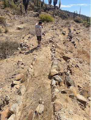
The mission at Velicatá was named San Fernando upon its founding on May 14, 1769. As part of the expedition to secure San Diego Bay for Spain, Junípero Serra would be leaving Velicatá. He placed Padre Miguel de la Campa y Cos in charge of the new mission. Besides baptizing 390 Natives, Campa y Cos had constructed an irrigation canal and a dam. The canal is still visible between the mission and the large reservoir, nearly a mile away.
Once the Franciscans had seen the land north of the peninsula, with all its potential and being free of European introduced diseases, they were easily persuaded to allow the Dominican Order to assume control over the peninsula missions. The Dominicans also would be adding their own missions between San Fernando and San Diego. The transfer was in July 1773, and it was not without a hitch.
The Dominican Padres, Miguel Hidalgo and Pedro Gandiága, had an altercation with the departing Franciscans who insisted on taking mission possessions, including grain, which was needed at San Fernando to feed those who grew it. Five hundred more people were baptized between 1774 and 1775. In 1775, with the closing of Mission Santa María and transferring its people, which raised the population of San Fernando to 1,406.
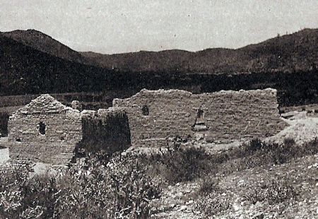
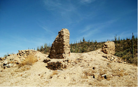
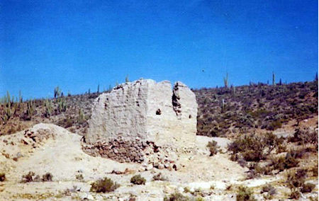
The mission land produced wheat, corn, barley, cotton, 110 head of cattle, 178 sheep, sixty-five goats, and thirty-one mules and horses, per a 1782 report. New adobe buildings that went up in the 1790s are likely what we see as the ruins of today. Most of the mission buildings vanished in the Twentieth Century, mostly from weather. Adobe bricks need a roof to protect them from rain. Sadly, damage also came from treasure hunters or just uninformed visitors. Only the two corners of the once tall chapel remain today from what was a mostly complete but roofless room seen in photos from the 1920s to 1970s. The new Transpeninsular highway was built less than three miles away, increasing the visitor count many times.
My first time at Mission San Fernando was in 1974, camping with a friend who was also 16 years old. I returned the following year and fortunately have the photos of the mission and ship-petroglyph from then to compare to 2025. I have returned to San Fernando several times, over those 51 years.
Reaching Mission San Fernando is fairly easy in a pickup or S.U.V.:
Exit Mexico #1 near Km. 121, at the abandoned El Progreso restaurant ruin. Drive south then go west along a fence for 2.3 miles to the mission site. The road continues on westward towards the cliff with petroglyphs just over ½-mile from the mission. In May 2025, the road was overgrown about halfway there, so we walked that last section. Along the way to the cliff, look for the aqueduct on the right, built soon after the mission was established. It ran to a large reservoir a mile from where it left the arroyo near the mission. View additional photos and maps.