 |
Article and photos by David Kier

On a 2009 New Year's weekend trip south to Bahia de los Angeles and beyond, we had the great pleasure to see the mysterious walls, dam, and palm tree that was described by Choral Pepper in her July, 1966 edition of Desert Magazine.
When Choral Pepper wrote her book on the missions and mysteries of Baja, seven years later, her research had her (and others) convinced she had discovered the 'started' mission of Santa Maria Magdalena described in Jesuit texts and shown on a Jesuit map. For some unknown reason, the project was aborted. Perhaps the water source failed or politics in Spain had called for a direct push to Alta California instead of circling the gulf and connecting with the missions on the mainland? One mission bell hanging at Santa Gertrudis (the closest mission south), is cast with the name Santa María Magdalena, a mission planned and reported started but never completed.
In the previous Baja Travel Adventures article (March 14, 2012) about the ruins near Mulegé, sometimes shown on maps as
 'Santa María Magdalena', is a possible explanation how they are related to these ruins near Las Animas. When we saw the site,
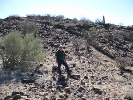
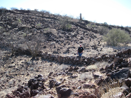
so little was changed from the photos and report of 43 years ago, it was as if we had stepped into a time machine. The location made for an ideal lookout on top of a small mesa just over a mile from the large bay. At the base of the mesa was an earth and rock dam that created a reservoir that either contained water from a spring or trapped rain water. Just beyond the dam is the trunk of a date palm tree, just as Pepper had described it when she and others on an expedition sponsored by (Perry Mason creator) Erle Stanley Gardner discovered the site in February of 1966.
'Santa María Magdalena', is a possible explanation how they are related to these ruins near Las Animas. When we saw the site,
so little was changed from the photos and report of 43 years ago, it was as if we had stepped into a time machine. The location made for an ideal lookout on top of a small mesa just over a mile from the large bay. At the base of the mesa was an earth and rock dam that created a reservoir that either contained water from a spring or trapped rain water. Just beyond the dam is the trunk of a date palm tree, just as Pepper had described it when she and others on an expedition sponsored by (Perry Mason creator) Erle Stanley Gardner discovered the site in February of 1966.
No exact location was provided, other than somewhere between Bahía de los Angeles and Punta San Francisquito and one Baja guidebook said it was about 40 miles from Bahía de los Angeles. Thanks to someones sharp eye looking at Google Earth satellite images of Baja, I got an emailed lead as to where it might be, as my search for it had been publicized on an Internet Baja forum. As it turned out, the site was 35 miles from the pavement at Bahía de los Angeles and 2 miles from the fishing camp of Las Animas.
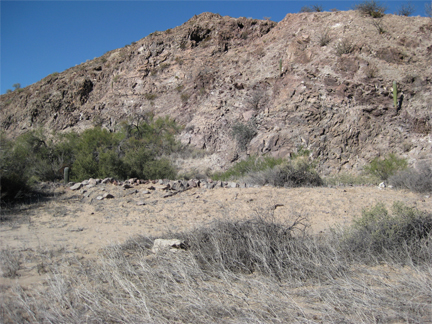
Besides the dam, palm, mysterious rock walls near the top of a steep climb up the mesa, there are many round clearings containing sea shells. Commonly called "sleeping circles" these native American sites are common in Baja California and indicate perhaps the builders of all these structures. The date palm may have been a seedling from earlier palms such as those planted by the Jesuits at other water sources? The top of the mesa is an ideal lookout for both arriving ships or the other direction for hostile Indian raids. A fort on top and the mission below would fit, but why the walls and what did they intend to do?
Baja California remains to be a place for adventure and discovery or re-discovery as in this case with 'Santa María Magdalena' near the bay of Las Animas. Seeing sites like this in person may help expand the knowledge of our past as it unfolded on the California peninsula.
Road Log
0.0 (0.0) Turn left (south) off pavement (by Xitlali Market), Bahía de los Angeles, on the graded road south towards Punta San Francisquito.
4.1 (4.1) Camp Gecko road to left, continue south.
9.9 (5.8) Las Flores Jail Ruins, 1/4 mile off to the right.
12.4 (2.5) Graded road curves to the left and a faint road continues straight, going to the cable line terminal, at the south end of the Las Flores railroad. Continue on graded road.
22.7 (10.3) A faint road to the right is the older route south, going down Valle la Bocana. A car door turned into a sign once marked the turnoff, but is gone. Continue on graded road.
26.7 (4.0) Turnoff left goes north to Bahia las Animas. Graded road continues straight. Turn left.
33.7 (7.0) FORK, approaching the mesa. Both roads go to Las Animas and rejoin on the opposite side of the mesa. The left branch is the more used route and runs 2.3 miles before rejoining with the right branch. Go right.
35.0 (1.3) PALM (just after passing near the dam and the edge of the mesa).
35.2 (0.2) Access to climb to the wall is off to the left.
35.9 (0.7) Rejoin with left branch road that came from the fork at mile 33.7.
37.9 (2.0) End of road at lagoon, just past fish camp on the beach at Bahía las Animas.

Fair price. Webpage could be improved.

Was quick, easy super straight forward!!

We had such an enjoyable day trip to Northern Baja, made simple and stress-free by Baja Bound. The...