 |
By David Kier
Since December 1, 1973, motorists have had a paved highway running the length of the Baja California peninsula, officially called Mexico Highway One. For most travelers this reduced a week or two of driving down to about 3 days, if you didn’t break down or get stuck!
What was it like before 1973?
My personal experience with the peninsular drive is from the summer of 1966, I was almost 9 and my job as ‘navigator’ was to read from Gerhard & Gulick’s Lower California Guidebook. That was the most detailed book on Baja California roads ever published and was known as the ‘Baja Bible,’ in its day. My dad had bought a Jeep Wagoneer the year before and our first trips with it were to Bahía San Luis Gonzaga, via San Felipe. Baja fever was strong with my parents and every school vacation saw us going south. The grand tour was to drive ‘The Road’ from Tijuana to La Paz, and on to the tip, Cabo San Lucas.
Preparing for the grand tour meant having supplies for at least 3 weeks because the road was unpaved for 800 of the over 1,000 miles and much of that was unimproved, ungraded, natural track. We met with Howard Gulick, the co-author of the Lower California Guidebook and the creator of the maps and road logs in it. A former co-worker of Mr. Gulick was one of my dad’s friends who had traveled with Gulick into Baja on some of his mapping expeditions in the 1950s and early 60s. Gulick gave us an update on the road to La Paz for our 1966 trip. He recommended camping spots, such as Agua Dulce and El Requesón. He told us of a new shortcut, near the end of Concepción Bay that cuts many miles off the drive to Comondú. Howard autographed our copy of his guidebook and I remember what he had said about where he signed the book. Howard said people like him to sign on the title page where his name is printed. I do the same when I sign my book, now!
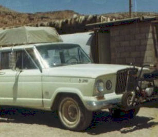
The Jeep was loaded up plus we had a roof-top carrier and my dad had oversized Armstrong floatation tires on custom rims. A second fuel tank was also added to provide plenty of range. The off-road industry had not yet been born so many things were customized for these desert expeditions.
Going south, the paved highway ended abruptly, 72 miles from Ensenada (4 miles north of Colonet). My dad would say, “Now, the adventure begins!” The road was a wide-graded bed as if ready for pavement that never came. The road was very washboard-like and uncomfortable driving for nearly 50 miles to San Quintín, where we spent the first night, next to the old mill building ruin.
The next day, we drove along the bayshore, passed the old pier, and looked at the old English cemetery where the colonists from the failed wheat growing and flour mill project had been laid to rest. Back onto the main road south, the grading was less obvious and no longer the elevated roadbed that was ready for asphalt. We popped into the Santa María Sky Ranch to have a look as this was a popular destination for pilots and sportsmen. The roof of the motel was covered in pismo clam shells. Today it is on the Los Pinos tomato growing fields and all the old buildings have been bulldozed over.
On the El Rosario mesa the road split, one looked very scary, plunging steeply down a canyon and had a stop sign. We took the other branch which ended shortly at the airstrip. So, we turned back and went down the canyon. My dad presumed the stop sign was to have you listen for any vehicles coming up the canyon since the road was too narrow for cars to pass by each other. In the old road days, it was rare to see another vehicle driving. If you did, that usually called for a stop to share details on what was ahead for the opposite direction driver.
In El Rosario, it was pretty mandatory to stop and top the gas tank from one of the gravity pumps that was filled by a hand lever. I am not sure if we used the first station (now Baja Cactus Pemex) or Mama Espinoza’s pump, just down the road. El Rosario was the last town of any size until San Ignacio. It was where the telephone line ended. Today, it remains at the end of the powerline, and telephone poles go no further.
The old and new road were the same until El Rosario. The highway route changed going south but still remained close to the old road, providing supply and support for construction crews. Paving arrived at El Rosario in early 1973 and that is when Mama Espinoza coined the phrase, “Bad roads bring good people… Good roads bring all kinds of people” as it was believed that bad roads acted like a filter keeping criminal types away. The four-wheel-drive travelers were a happy bunch on the thrill of a lifetime. In 1967, Americans created the Mexican 1000 race (renamed Baja 1000, in 1973) and El Rosario would be one of the checkpoints. There already had been some published fastest times to La Paz by motorcycles and four-wheeled vehicles. Manufacturers saw this as an advertising bonanza. The rest is history!
A few miles from El Rosario is a prominent cliff that resembles a castle, called “El Castillo.” This is where the old road left the valley and headed into the boojum tree covered hills. The new highway leaves the valley sooner and the famous cliff is a bit more distant and a less obvious landmark. The next section was where four-wheel-drive may have been first employed to climb the infamous Aguajito grade and passed by a turquoise mine. After the boojum hills several ranches were located that served travelers with food, drinks, and gasoline, as a side business. One ranch was San Agustín which was most popular because it had a kerosene refrigerator and sold cold beer! The ranch began as the water supply for the onyx mine town of El Mármol, 10 miles away, on a side road. The well-water at El Mármol was not drinkable.
Our camping spot at the end of the day was Agua Dulce. Located just off the main road where a pool of water was down in a gully. This spring is on the mission road, El Camino Real and has been a major point for survival from ancient times. The Jesuits discovered it in 1766 and Franciscan President Junípero Serra was here on his expedition to San Diego in 1769. In 1973, highway crews needed the water and graded a road from the new highway to here, destroying some of the natural beauty it had. On my most recent visit in 2017, the area looked regrown and a ranch is now located near the spring.
Our next camping spot was south of Punta Prieta which was about a hundred mile drive that day. Not long after we began unloading to camp, a truck drove up and warned us the area was infested with rattlesnakes! Well, needless to say, my folks packed the Wagoneer back up and we moved to another spot!
The old main road went to the center of the peninsula where the village of El Arco was located. This was just north of the border with the territory of Baja California Sur. When Highway One was built, it went directly to Guerrero Negro and bypassed El Arco totally. A paved side road to the former gold mine town was made but the blacktop was paper thin, and all gone in about 10 years. Today, El Arco is a ghost town with just a cattle ranch operating in the center of the empty homes and former military base.
At Rancho Los Angeles, there was a van taking on passengers after a break in their drive. It was a bus service. The sun was getting low and my dad figured we could get to San Ignacio following the van even if dark without fear of taking a wrong fork in the road. In the old days, the main road was often no different looking than a side road and usually no signs. The Lower California Guidebook was invaluable for finding the road desired but there were many forks in the road not in the guidebook. We would learn that these forks usually came back to the road we were taking and were only detours around bad places in the road.
It was dark when we drove into San Ignacio, the town was pitch black (no electricity), we missed seeing the oasis and the mission, and just kept moving along in the night. I had fallen asleep but awoke when we arrived in Santa Rosalia. My parents told me of the hairpin switchbacks that required backing up just to get around on the road between San Ignacio and Santa Rosalia. We didn’t like the looks of the hotel there so ended up camping on the beach north of town. The sun would be rising in just a few hours.
Not spotting any kind of gas station, my dad motored south to the Rancho San Lucas airfield (now a military base) and purchased aviation fuel to fill our tanks. My dad said the Jeep wanted to fly on that gasoline! The road was now well-graded and smooth for the 40 miles to Mulegé where we would take a break in the drive. My folks saw a young person with a bunch of mangos. This was a thrill for them, I recall. The boy sold them for one peso (= to 8 cents then). My folks showed him dimes and pesos, he could choose (dimes were more valuable, but tiny in size). He chose the big peso coin.
Later, down the road we camped at El Requesón, the sand spit that connects to the island at low tide. That was a wonderful place. The butter clams were thick in the water and might be where I learned to like them. I found a large piece of black obsidian on the island, too. A little boy from the ranch was admiring my lunar rover toy and so I gave it to him. El Requesón would be a favorite place to camp in following years with us.
The main road along the bay was cut right into the side of the cliff or was splashing in the water of the bay. Today, the old road can be seen in many places along Concepción Bay and parts of it are even used to access camps, like El Coyote and La Perla. Near the south end of the bay, we took the new short cut mentioned by Howard Gulick and then was a very rough and steep drive to Comondú, yet, this was the main highway to La Paz in the 1960s, and earlier. In San Miguel Comondú, there was a small fiesta next to the road. A turtle was being cooked on a fire in its own shell with vegetables added in, like a stew. The people invited us to stay and enjoy the feast. I think my parents were a bit grossed-out with the exotic food cooking, so they kindly declined.
The road on to La Paz would soon become a long straight, graded, washboard nightmare and pavement began about 100 miles north of La Paz, which was a huge relief after the nearly 100 washboard miles. We would stay at the hotel in La Paz and check on the ferry situation for the trip across to Mazatlán for the paved, mainland drive home.
The next few days would be spent driving the loop around the cape region. The highway south from La Paz was paved for just ten miles then a new roadbed was graded to just past San Bartolo where the typical single-lane dirt road continued on to Cabo San Lucas. We first went to Los Barriles and stayed at the Bahía de Palmas resort and after a couple days, tried the Rancho Buena Vista resort. These places were primarily frequented by private pilots as each place had its own runway. Meals were served family style on a long table. When asked about flying in, my dad said that we drove. Surprised, the other guest then asked if we took the ferry over from Mazatlán. Again, my dad said no, that we drove all the way down from Tijuana. The man’s eyes widened and jumped over to say, “Let me shake your hand!”. Yes, it was that big of a deal.
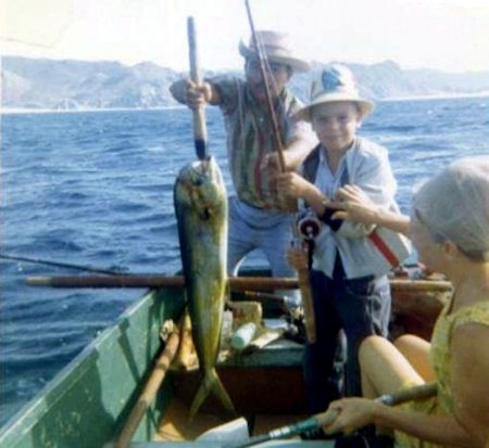
At Cabo San Lucas, there was the Hacienda Hotel on the big beach and not much else. Airplanes landed on the salt flat behind the hotel that today is the marina. We hired a panga to go out around the cape for some deep-sea fishing and I landed my first dorado!
Going back to La Paz, we went via Todos Santos. The road to Todos was just a simple pair of tracks in the sand. From Todos Santos back to La Paz the road was a wide, graded road. We boarded the ferry and sailed to Mazatlán for the long but paved drive home.
Baja became seared into my soul at an early age and its spirit has never left me in more than fifty years.
About David
David Kier is a veteran Baja traveler, author of 'Baja California - Land Of Missions' and co-author of 'Old Missions of the Californias'. Visit the Old Missions website.

I have had some unexpected things happen to me in Baja and Baja Bound has always performed for me. ...

I always purchase my Mexican insurance with Baja Bound. Unlike other Mexican - American insurance...

Fast and easy quotes and affordable prices