 |
By David Kier
The possibility to see ten mission-era sites, ranging from complete churches to stone ruins to just a location where a mission once stood, exists in a relatively small radius out from Loreto.
The Baja California traveler can make a connection with the past of Old California. Roads range from paved highways to easy graded dirt roads to rough places suitable for only four-wheel drive vehicles. Most mission sites can be driven right to, but a couple will require some hiking. The locations can be part of a day trip or done with overnight camping or lodging. The longer you are out in the backcountry of Baja California the more you may be able to connect with her past and soak in the scenery.
As with any travel article, know that conditions can change between the research and your visit. So, use this to plan where to go but be flexible if the road, locations, or businesses mentioned have changed. Enjoy this and all Baja travels and make it an adventure to remember!
Loreto is where California’s Spanish missions and El Camino Real roadway got off to a successful beginning and operated 125 years before Spain was defeated and the Mexican Empire was recognized in the Californias as the legitimate government. The first California mission and its museum, in the center of Loreto is your starting point. GPS: N26°00.62’, W111°20.61’.
Ligüí is reached south on Highway 1, 21 miles and is the site of the third California mission, founded in November 1705: San Juan Bautista de Ligüí (later renamed: de Malibat). Turn off to the left at the school for the village of Ligüí, between Kilometer markers 85 and 84 taking the dirt road east. In 0.4 mi is a fork, the left branch is signed for the beach (Playa Ligüí) but was badly damaged by flash floods. The right fork crosses the arroyo to another fork, left to the beach (0.5 mi) and right to the village of Ensenada Blanca (1 mi). The location of the mission was on a ledge overlooking this arroyo, but the arroyo has widened with each flood the past 45 years since the highway was built (and blamed for the destruction). The last time some mission rubble was visible was in 2001 and now just this location remains, in the center of the arroyo, between the two road forks. GPS: N25°44.35’, W111°15.88’.
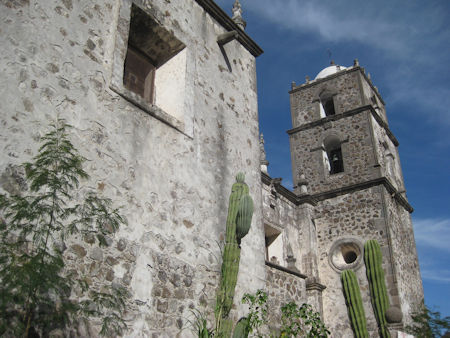
San Javier is the second California mission. It was founded in 1699, in a mountain valley, west of Loreto. The first location for Mission San Francisco Javier de Biaundo is today known as Rancho Viejo and is just to the right of the paved road to San Javier (at Km. 25.5). The mission was relocated 5 miles south in 1710, (now Km. 34) at the end of the paved road in the small town with a magnificent mission. It is perhaps the finest example of Jesuit construction. The cut stone church was built from 1744 to 1758.
Comondú is reached by traveling back north from San Javier for 4 miles, to a junction at Km. 27.5 (unsigned in February 2017). The road to San José Comondú is graded but two steep grades with loose, large rocks (Mile 9 and Mile 13 from highway) will require good ground clearance and four-wheel drive until crews finish repairs. At Mile 15 from the San Javier highway is El Horno (‘The Oven’) a ranch next to a large stone kiln used for making lime which was needed for the building of the once giant mission church of San José de Comondú.
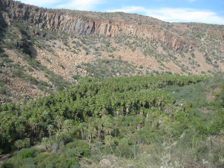
After dropping into the oasis canyon and village, arrive at Mission San José de Comondú at Mile 25.7. The mission seen today was but a side chapel to what was once the largest church of all the California missions. The mission was founded in 1708 then relocated here in 1736. The giant mission church was built between 1754 and 1760. That church fell into ruin and was demolished in 1936, except for the chapel we see today. 0.4 mile past the mission is the road north to San Isidro and La Purísima. 1.8 miles after the La Purísima junction is the larger town of San Miguel Comondú. It features a little boutique motel with restaurant and museum. A paved road south to Highway 1 at Ciudad Insurgentes begins at San Miguel Comondú.
La Purísima is reached by going back towards San José Comondú for 1.8 miles to the road for San Isidro and La Purísima. It cuts across the canyon floor to the opposite bank then climbs up and out of the Comondú canyon. It is a little rough and rocky at first, but soon smooths out and becomes an easy drive. 18.2 miles from the road between the two Comondú towns is the road between La Purísima and Highway 1, to the east (see below). Most traffic goes to the west here as you are once again in tropical farm land. In 2.3 miles, the road becomes paved as you enter the town of San Isidro. In 2.3 more miles, you arrive in La Purísima. A sign points one block to the right for the mission site. Ahead, on the left is a market (ice sold) and on the right, at next corner, is the restaurant ‘Otho’. Behind or next door, is a small motel, ‘Posada del Angel’. A seafood dinner (including a beer) was $125 pesos, and a room (with satellite TV and hot shower) was only $250 pesos.
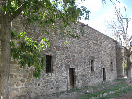
The mission site is on the street just north of the motel and a block east. All that remains to show of this once important mission are two tombs. A home surrounded by a fence is on top of the mission church location, next to the tombs. Mission la Purísima Concepción de Cadegomó was founded in 1720 and operated for over 100 years. Nearly 2,000 native California Indians made up the mission in 1730 but that number dropped to just 61 by 1800. The mission closed around 1826 and Mexican farmers moved into the area to take advantage of the farmlands. Irrigation canals built for the mission still serve the needs today. Some of the canal system is seen from along the road.
The paved road continues south from La Purísima to meet Highway 1 at Ciudad Insurgentes. Those seeking more adventure can take the rough road east to Highway 1, between Mulegé and Loreto, at Km. 59+. When traveled in February 2017, the road east was very rough and in need of new grading. The 35 miles from La Purísima to Highway 1 required 3.5 hours to drive. Two points of interest going this route include the view of the La Purísima valley from the steep climb, just a mile east from the Comondú road junction and a 7-mile side trip and short hike to see the 1708 mission ruins at Comondú Viejo.
Comondú Viejo is accessed 25.6 miles from La Purísima (11.0 miles from Highway 1, Km. 59+) using a well-traveled ranch road going south. It leads 6.4 miles to Rancho San Juan (4WD suggested). One cattle control gate is along the way. Always re-close gates after passing through. The road goes past the home and goat pens at San Juan, and ends a kilometer beyond, where the river has washed it out. Park in the clearing before the washout for an easy turn-around and begin the hike. Pick up the old road on the opposite side of the river and walk it south a half mile where it crosses the river once again. Just south see some stone piles and look just east. The ruins are heavily overgrown. The ruined stone home of Padre Mayorga is at N26°16.450’, W111°43.140’. The church was next to the home, but being made of adobe, has vanished in the 300 years since its construction in 1716. Stone walls for the mission farm are 200 feet to the northeast.
The final miles to Highway 1 become smooth and fast. Turning south, towards Loreto the highway passes near two more mission-era projects:
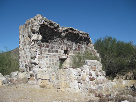
Londó and San Bruno. Just a few meters south of the Km. 30 marker, take a road to the right to see the stone ruins of San Juan Londó, just 0.4 mi west. This was an important visita of the Loreto mission, that later was transferred to the Comondú mission. It had been considered early on to be a mission and early modern travelers thought such a structure was a mission, not just a visita. At Km. 26+ a road heads east to the area of San Bruno. San Bruno was a failed attempt to colonize California from 1683 to 1685. The oldest California Spanish fort ruins are located there.
About David
David Kier is a veteran Baja traveler, author of 'Baja California - Land Of Missions' and co-author of 'The Old Missions of Baja and Alta California 1697-1834'. Visit the Old Missions website.

I've had Baja Bound insurance for more that ten years now with thousands of miles logged in Baja....

I've used Baja Bound many times. I've purchased online with no problems. I will keep using them....

Check them out - best place to get Mexican Insurance before you leave for your trip/vacation