 |
By David Kier
In 1708, the Jesuit missionary Julián de Mayorga founded the fifth mission on the peninsula called California. The Spanish still were unclear if this new land many believed to be an island was indeed connected to the mainland. The initial goal of the padres was to convert the wild Indians into civilized Spanish subjects. Missions were the first step in this method of colonization.
The first successful California mission was founded at Loreto, in 1697. Missions at San Javier, Ligüí, and Mulegé followed. Where water flowed, land could be cultivated, and Native people lived, is what made potential mission sites. A pledge of financial support and an available priest were the final ingredients to a mission being established.
The location of the new mission was called Comondú by the Cochimí Indians and the benefactor who financed the project was José de la Peña, the Marqués de Villapuente. Mission names often were a combination of the benefactor and local names. San José de Comondú would be one of the most successful missions, but in 28 years it was moved over twenty miles to the south. Most everyone who travels in Baja California knows of the two oasis villages with the name Comondú (San José and San Miguel). They have that name because the mission didn’t change its name when it moved in 1736.
After the mission moved, the original site became known as Comondú Viejo (Old Comondú). Until the early 1970s, it was located along the main peninsular road to La Paz, between Rancho San Juan and Rancho La Presa. Now, 44 years after the highway down the length of Baja was built, Comondú Viejo would vanish from modern traveler’s sight. Even the old main Baja road would be bypassed by another road and the original would be totally washed away by violent flash- floods of the past few years.
The last photographs I had seen at Comondú Viejo were taken in 2002 by Jack Swords. I have seen no newer reports on Comondú Viejo since then. 2017 would be the year for a fresh visit to the this, the first mission of Comondú.
In February, I traveled to eight of the missions and a few other mission-era sites in my quest to learn more of the locations. Last year, I published Baja California Land of Missions to provide the most complete story of all 27 missions and many other historic locations on the peninsula. Updates to the book are provided on my missions Facebook page and I just find it fascinating to be on the sites where so much energy was consumed trying to colonize this exotic land, as distant from Spain as Mars is, in today’s travel times!
Getting There
The closest approach is from Highway 1, at Km. 59, between Mulegé and Loreto. The graded road west is signed for San Isidro. The dirt road is fast for only a few miles and then deteriorates. 11.0 miles from Highway 1, take the ranch road to the left (south). It is well traveled. The road on west to San Isidro and La Purísima (25.6 miles) is very rough and required 3 hours of uncomfortable driving.
Now driving south, in 2.5 miles is a closed cattle control gate. Re-close it behind you. Pass the driveway to Rancho San Cristobal at 3.0 miles and a cattle guard at 4.0 miles. At 4.2 miles is a fork, the road to the right showed no traffic but was a ‘newer’ road to the twin Comondú towns. Our road to Comondú Viejo and the original Transpeninsular road, is to the left. The road climbs high on the right side of the riverbed then crosses the river and climbs high to get around a cliff (4WD here) before dropping down into Rancho San Juan, 6.4 miles from the San Isidro road.
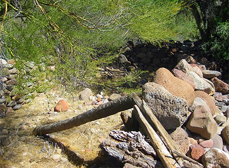
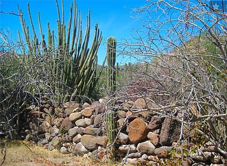
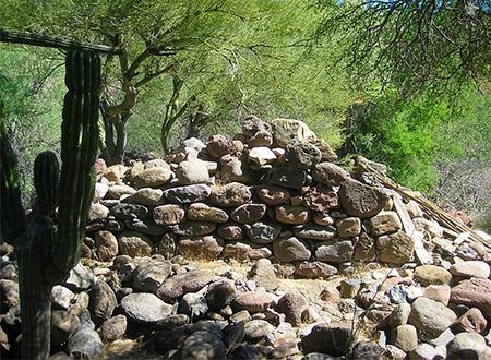
Pass the ranch house and goat pen heading south. There may only be animal tracks on the road. In a kilometer (0.6 mi.), park at an easy turn-around spot. The road just ahead is impassable and is without a turn-around. The mission ruins are just over a half mile hike from here. On foot, you will walk across the river where the road once was, pick up the road on the right side to where it re-crossed the river. Then, walking south and then east, find the stone ruins of Padre Mayorga’s house. It was next to the adobe mission church, and there are other walls nearby. The walls are well hidden by the desert vegetation. A GPS is a must to find the site, today, as it is nearly lost to the modern world.
The priest’s house ruins are at N26°16.45’, W111°43.14’ and other walls are just northeast. The mission church was made of adobe and nothing remains of it, next to the house, forming the long line of a letter L (with the house being the small line).
Explore, and photograph your discoveries. Water canals, the Camino Real road, and other mission-period construction beckons more time be spent at this 309 year-old site.
About David
David Kier is a veteran Baja traveler, author of 'Baja California - Land Of Missions' and co-author of 'The Old Missions of Baja and Alta California 1697-1834'. Visit the Old Missions website.

