 |
By David Kier
The first influx of travelers to Baja California followed World War II, thanks to the creation of the civilian Jeep, the Willys station wagon and pickup, as well as the Dodge Power Wagon and other four-wheel drive vehicles. Many, if not all the dirt roads of Baja were soon traveled which opened up the backcountry that most of Baja was at the time.
Howard Gulick, an engineer with the City of Glendale took it upon himself to travel and document all the roads and make professional, hand-drawn road maps of the peninsula. Those logs and maps were published and updated in four editions and two additional printings of the Lower California Guidebook from 1956 to 1970.
Sadly, Howard’s original, large-scale maps were edited to fit the book, and many lesser used roads were not included in the published work. Still, Mr. Gulick’s guidebook maps were the finest maps of the peninsula for many decades, even though paved roads began to erase the mystery of what was out there.
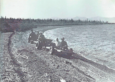
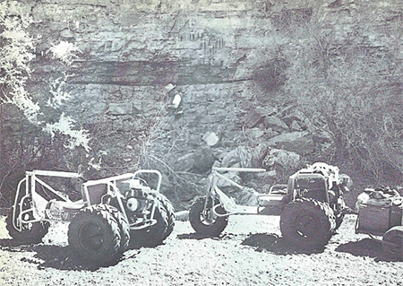
In 1966, world famous mystery author and the creator of Perry Mason, Erle Stanley Gardner, was exploring Baja California with a group of associates using four-wheel drive vehicle, custom made dune buggies, and ATVs. Gardner loved the desert and Baja California. It offered him an escape from the demands of Hollywood TV producers. He also utilized helicopters and airplanes to explore and to shuttle TV scripts back and forth between his Baja camps and Hollywood.
Gardner enjoyed camping on Bahía Concepción and looked across to the other side asking anyone he could, “what is over there?” He got shrugged shoulders. That was just no good, he had to find out! The maps of the 1960s showed no road on the on the 30-mile-long peninsula that creates the bay.
However, if one read all of the Lower California Guidebook, in the chapter called Places Reached by Sea, Gulick writes: “There is an old road, no longer used, on the east shore of the bay running out to Punta Concepción, where there is an abandoned manganese mine.”
Erle Stanley Gardner did not mention the mine but did show the petroglyphs of Arroyo los Pintados as well as the landing strip his team made so Captain Francisco Muñoz could land his plane over there and ferry TV scripts and supplies while Erle and his team were exploring.
The next mention of the other side of Bahía Concepción comes in the 1977 guidebook by Jim Hunter named Offbeat Baja in which he details the 34-mile road to the manganese mine, which is on the east side of the peninsula, opposite the entrance of the big bay.
An excellent article by Bob Vinton appears in the November 1991 edition of the Baja Explorer magazine in which he provides details and color photos of the trip out to the Gavilanes manganese mine, which employed nearly 7,000 people until it closed in 1948.
In the 1996 off road guide to central Baja California, Backroad Baja, by Patti and Tom Higginbotham, the 34-mile road to the tip and mine is detailed. The mystery would seem to have been solved? Not quite the case! No amount of writing or photographs and maps can relay the experience of actually driving little used roads in the wilds of Baja California.
In September of 2016, four off road vehicles attempted to reach the end of the road and here is the story:
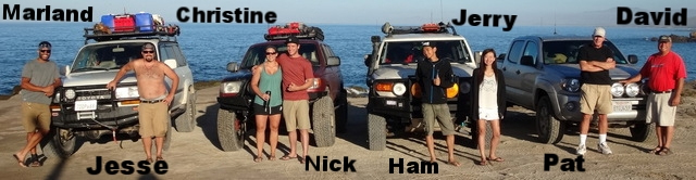
Jesse Hansen is an executive chef at a major hotel and oversees the activities of dozens of people in his kitchen. This requires no lack of skills and planning on a daily basis. Jesse owns two four-wheel drive vehicles and off roading is a way for him to unwind and have fun. The Baja Extreme Tour of 2016 had been planned for months and with several modifications to the original route, which I suggested to get the maximum fun over the 11-day adventure, going to the end of the Concepción Bay peninsula was one of the activities planned by Jesse that would be unaltered.
Riding with Jesse in his Toyota Land Cruiser wagon was Hollywood actor and model Marland Burke. Three more vehicles were part of the Baja Extreme caravan. A Toyota 4Runner with Nick Helton an engineer and Christine Joy a physician assistant, a Toyota FJ Cruiser with ‘Ham’ an electronics genius and his sister Jerry, and my Toyota Tacoma with Pat Malone a real estate investor and I, as the tour guide.
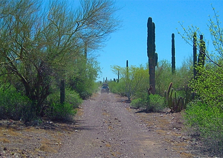
On Day 5 of the 11 day Baja Extreme tour, we drove from San Ignacio to Bahía Concepción and check in with Mark, Olivia, and Nathan at Playa Buenaventura to hear of any reports from the other side. Mark suggests we avoid the mud beds on the first access road (Km. 76) and go another mile south (nearly to Km. 74) for a dry road to the other side. We enjoyed a fabulous meal created by Olivia and head on down the road. Once off the highway, we deflate our tires about 30% for improved traction and reduce possible rock punctures.
While we did not reach the point that evening, what we saw and experienced the two days we were on the other side, left a lifelong memory for us of how extreme Baja can be! The following road log describes the road we took exploring the other side of Concepción Bay:
0.0 Highway One near Km. 74. Well used road goes east and northeast.
0.4 Pass to the right of a ranch, continue northeast.
1.0 Junction with pre-1970 main road between Tijuana and La Paz. Road heads east.
3.7 Fork, leave old Baja main road and take left branch going northeast.
4.7 Junction with mud road from Km. 76. Head east.
5.5 Fork, go left (north) to head up the Concepción peninsula.
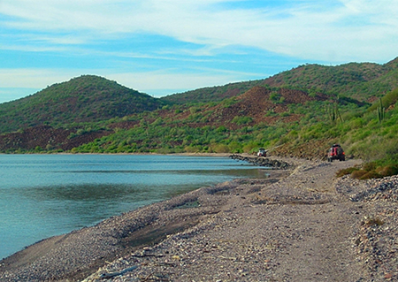
6.3 Come alongside the shore of the bay.
7.2 Mudflat. The route from/to Arroyo Tres Marías (3 miles) is to the right, near the base of a hill. Road to Punta Concepción continues north. Curve around to the right of any water or deep mud. The 4Runner got stuck here going straight, the rest of us easily went around and pulled him out.
9.8 Three cardón cactus stand side-by- side, next to the road, marking the south bank of Arroyo los Pintados. The access to the painted cliffs (about 1.6 miles) and our route to Arroyo Tres Marías 4x4 trail (see below) is here.
15.2 Road heads uphill and away from coast. Fence gate (if closed, keep it closed after passing).
16.8 Road turns downhill and returns towards coast.
19.7 Road nears flat area of Punta Amolares (where we set up camp at midnight).
The road on north becomes less traveled and is overgrown by thorny bushes and trees. Only motorcycles recommended beyond here.
25.6 End of road for us, deep gully washout ahead.
Arroyo Los Pintados/ Tres Marías side trip from Mile 9.8, above:
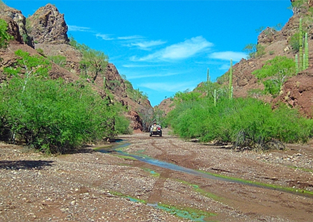
0.0 Drive east in sandy arroyo, away from coast.
0.7 Fork. Los Pintados is left fork and the canyon entrance is a mile away. We take the right fork and soon find an old road leaving the arroyo to the right.
1.4 After a difficult gully crossing, the old road drops into Arroyo Tres Marías and we turn left to follow it. Eventually coming to running water, we are encouraged to follow it further.
1.9 An old road to the right (hidden by brush) is how we left the area and avoided the gully crossing. It is 3 miles to the coast road junction at Mile 7.2.
3.6 End of road, former Rancho Tres Marías ruins. Spring ahead and to right in side ravine with fence along right side.
About David
David Kier is a veteran Baja traveler, author of 'Baja California - Land Of Missions' and co-author of 'The Old Missions of Baja and Alta California 1697-1834'. Visit the Old Missions website.

My wife and I were in Baja the 1st week of October. Insurance through Baja Bound was quick and...

Driving down the Baja from Canada. I needed Mexican insurance. I was able to buy it online from...

I've been a Baja Bound Insurance customer since 2006! They're the absolute best. #slowbajaapproved