 |
By David Kier
This is about an adventure I planned for months and dreamed of for years. Growing up with adventurous parents who loved exploring Baja California, I was destined to carry on the torch!
As a kid, sitting between my mom and dad, it was my job to read from the Lower California Guidebook as we traveled south, making sure we took the correct fork-in-the-road. The Guidebook was so professionally written that getting lost was almost impossible. Shortly before I turned sixteen, we again traveled south on Highway One. It was the summer of 1973, and Mexico was rapidly building a paved highway where it was just a single-lane rough road before. I took notes on the mileages at various points and the new highway’s progress was of great interest to people back in the United States. I created a guide to the new highway and to the old road, still in use. It was an instant hit, it even appeared on TV and the local newspaper!
I had hoped to drive the entire old road myself, maybe even race the Baja 1000! Well, Mexico managed to complete the paving of the Transpeninsular Highway before my first opportunity to drive it. However, the road south of San Felipe was still untouched and even had the most difficult section of road in Baja California, from Puertecitos to Gonzaga Bay.
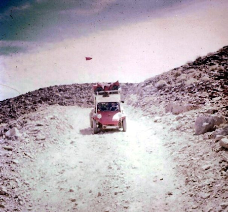
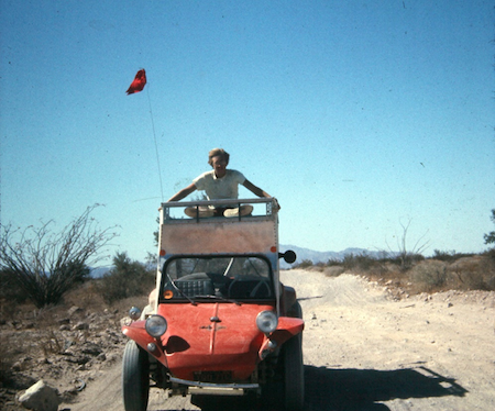
My friend, Pat Goforth, was also sixteen and his parents joined mine in consenting to this trip. We obtained the notarized permission slips that are required if traveling in Mexico when under age 18. My vehicle was a VW-powered, Myers Manx dune buggy, with a roof, rack, and side curtains for wet weather. We had the vacation week of Easter for the trip, and I designed a route that would be a grand tour with maximum sites, dirt road driving, and beach time.
With the buggy loaded, we were off on our first ‘non-parental’ trip into Baja! We sailed into Mexico with no concern coming from the border officers. The immigration checkpoint back then was located south of Maneadero. That was where foreigners are asked to stop and present their tourist permits (or ‘tip’ the official to fill out one there). Cruising down the highway, with open sides, in my buggy, was fun and made you feel really close to the road, like riding a motorcycle or topless Jeep.
When the highway was completed at the end of 1973, it came with the convenience of ‘paradors’ or rest stops. Each parador had a gas station, trailer park, cafeteria, an indoor air conditioned rest area, even showers. Most also had a hotel nearby, if not right there. Paradors were built at San Quintín (Santa María area), Cataviña, near Punta Prieta where the junction to L.A. Bay was going to be, Paralelo 28° (state border, near Guerrero Negro), and San Ignacio. A ‘mini-parador’ (gas station and trailer park) was also built at San Agustin. We got gas at the first parador and again at the Cataviña one on the following day.
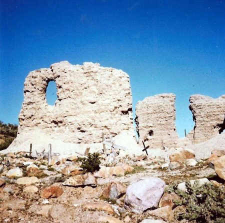
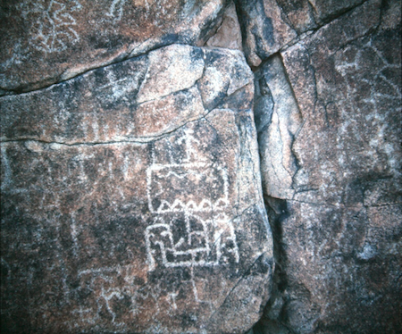
My plan for the first night was to camp at Mission San Fernando. The mission was magnificent to see and much of the adobe church walls were still standing, including window openings. Today, the mission is all but gone, possibly from foolish treasure-hunters mining the walls. We had arrived early enough to do a hike and look for the petroglyphs I had read about. They were about a half-mile down the big arroyo on the cliff. They were fascinating! Such unusual designs, and even what looked like Roman numerals along with an odd figure some say resembles a Spanish or Viking ship!*
The following day, our goal was Gonzaga Bay with a side trip to the abandoned El Mármol onyx mine and the El Volcán onyx geyser. El Mármol was famous for having the world’s only schoolhouse made from blocks of onyx. The school was locked, but looking through one of the windows, I saw desks and chairs. Maybe if the demand for onyx returns, this would be put back to use? On my future trips here, the door was open. Years later, the schoolhouse was partially torn down. So sad that it could not be preserved. There was plenty of onyx to gather, laying about. There was no need to tear down half of the school.
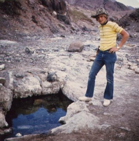
We next looked for El Volcán, the cold-water, 60-foot-high geyser, which erupts monthly. The road there crosses a big arroyo four miles from the schoolhouse, then passes a mineralized slope with several springs bubbling out. I presumed that was it, but years later, I would learn the true El Volcán is a short hike up the arroyo that the road had crossed. It is quite something to see, but I have yet to witness an eruption!
We returned to El Mármol and then took the old south road from the onyx quarry. You can see it climbing the hill from the schoolhouse. It eventually reaches the old main (pre-highway) road to La Paz and soon there was a connecting road a mile to the new highway, in the area of La Virgen. Parador Cataviña was next, and I topped the gas tank, chatted with a Green Angel truck driver, and we made lunch. It was a long drive south, past Laguna Chapala to the shortcut road for Calamajué. It is located six miles north of El Crucero, where the old gulf route meets the Transpeninsular Highway. This new dirt road was built for water trucks during the highway construction just a few months earlier. Water flows year-round in Calamajué canyon, so the construction crews made use of it. They had done the same with the historic spring of Agua Dulce, on El Camino Real. That spring is located not far from where the southern El Mármol road joined with the old main road.
Now heading north, we soon were on a water-covered road, but my buggy had no issues. We came out of Calamajué Canyon by the gold mill ruins and the 1766 mission site. The Jesuit padres had hoped the water would grow abundant crops of wheat and cotton, even though it was too mineralized to drink. Sadly, the crops withered and died. After just seven months, the Jesuits moved the mission from Calamajué to Santa María, located in a mountain valley west of Gonzaga Bay. The water at Santa María is sweet.
The next point-of-interest on our drive was Las Arrastras where down in the arroyo, gold mills once were used to grind ore, and good water comes from a deep well. Today, Coco’s Corner is located at Las Arrastras. About three miles beyond Las Arrastras was the dirt road west into La Turquesa Canyon. Pat and I drove to where the road seemed to end, by green pools of water. It is amazing how much water is in the desert! On a future trip here, I walked the additional mile to a small turquoise mine. This road is now passable all the way to Highway One, but it is a steep 4x4 road and was used for a recent Baja 1000 race.
Gonzaga Bay soon came into view, and it was a lovely sight. I managed to puncture a tire rushing to that attractive bay. At Alfonsina’s Resort, they repaired tires. A tire patch was installed and held for the remainder of the trip. We camped a couple of days on Gonzaga’s big beach, just beyond the row of homes. We needed a good rest as the next day’s drive would be over the steep grades of the old road to Puertecitos. Along the way, the waterhole of Agua del Mezquitito was visited. It was just a half-mile off the road.
Our final camping location was Nuevo Mazatlan, about twenty-three miles south of San Felipe. It was a popular place and with the shade trees planted a few years earlier, a most enjoyable campground, next to a big sand beach. Other campers were there, including a young lady. Pat and I each tried to gain her attention. Boys will be boys! Overall, the dune buggy was great and worked as well as a four-wheel-drive on the bad roads and beaches of Baja.
The drive back home to Escondido, in California, was long but uneventful and I was sold on going back to Baja as often as I could. The next Spring Break, a different friend joined me along with two other vehicles who heard about the trip and saw my photos from the previous year. It looked like I had a tour service started at 17, Viva Baja!
*See David guide TV’s Scott Wolter (America Unearthed) to the San Fernando Petroglyphs in 2019 here.
About David
David Kier is a veteran Baja traveler, author of 'Baja California - Land Of Missions' and co-author of 'Old Missions of the Californias'. Visit the Old Missions website.

Very good ans very fast. We hope all will ben good if we need it.

Caesar Hotel being one of the most internationally known restaurants out of Tijuana being born in...

Great service and prices!