 |
By David Kier
Throughout the years I have had the distinct privilege of writing about a wide variety of fascinating locations. While many locations remain virtually unchanged over the past eight or more years, an updated review seems to be in order following my recent trip south.
The missions played an important role in Old California's history, beginning on the peninsula originally named California. The Jesuits identified Velicatá but were expelled by Spain before founding a mission there. In 1769, the Franciscans established San Fernando at Velicatá during their northern expedition to secure ports like San Diego and Monterey, aiming to prevent Russian expansion in North America.
In 1773, the Franciscans agreed to share the California mission lands with the Dominican Order. Between Descanso and San Diego was where California was divided. The Dominicans got what we now call Baja California. They would also have plenty of unconverted land between the missions of San Fernando and San Diego to establish their own missions.
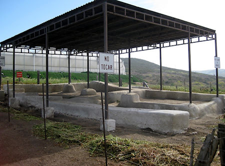
After crossing the border into Mexico, the first mission to revisit was El Descanso (1/2 mile east of Km. 49, off the free road). There has been almost no change since my 2017 visit, with the exception of a fence and signs not to touch the site, located right behind a modern church. Descanso Valley was the site of two missions and there is a bit of confusion with that. Around 1810, floods at Mission San Miguel (10 miles south) caused it to be moved to this valley for about four or five years and this was named San Miguel la Nueva. A book from 1935 had estimated the year was 1817 and that year keeps getting mentioned even though Dominican papers (made public in 1960) provided the actual time of the short-lived relocation. In 1830, a different Dominican took it upon himself to build a new mission here, naming it El Descanso. As this was well after Mexican independence, there is no Spanish mission connection other than this padre was originally stationed at San Miguel, in 1815.
My previous visit and mission history here.
Ten miles down Mexico #1 is the next mission, San Miguel (Km. 65.5, next to a school, along the highway). Founded originally seven miles east in 1787, it was moved here the following year. Read about it in a past article.
In 2025, the mission ruins looked unchanged from 2017. The gate to walk among the walls was locked (on a Saturday) so the photos would be through the fence.
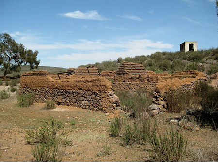
Continuing south of Ensenada, to Km. 50, is the small town of Santo Tomás, named for the mission founded in this lush valley back in 1791. After two moves the mission’s final home was just a few hundred feet from the highway and just north of the El Palomar Campground. Sadly, the El Palomar campground has closed as well as the Pemex gas pumps, store, and restaurant. These businesses have been such a major landmark and source of many events over the decades.
Santo Tomás was the final California mission to remain in operation. The Dominican here was so upset when he returned from a visit to San Diego to learn one of his Native members had sold altar valuables to some gold rush seekers that were passing through in 1849. Almost nothing remains of mission but a bit of adobe wall. We asked permission to walk through a home’s property to take photos. It was a little less in size from my 2017 visit and more difficult to get to with the campground closed. Read about this mission in a past article.
Continuing south on Mexico #1 to Km. 88.5 for the signed road west, going less than a mile, to the very impressive mission site of San Vicente. Located on a bluff overlooking the valley, the mission is just north of the modern town of that name. Unlike the previous three missions, San Vicente has a devoted parking area, paths, and information signs for a self-guided walking tour. Since my previous visit in 2017, some of the protective plaster coatings have fallen to expose the original adobe bricks. Read more about San Vicente here.
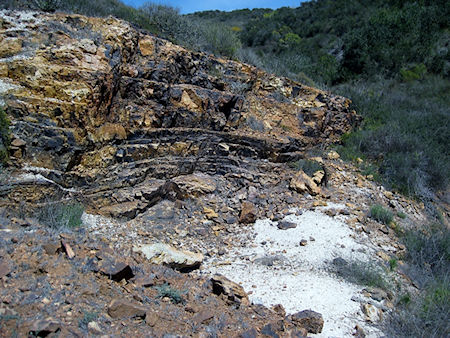
Not a mission, but a point of interest I have written about is the Albertino barite mine. The Auto Club had included it in their guidebooks and maps for several years (1951-1966). Last May, my friend and I saw where this was, 3.7 miles east of the Punta San Jacinto shipwreck sign, at Km. 149.8. Read more here.
The next point of interest as we travel south on Highway One is the mission of Santo Domingo. Located five miles east of Km. 169 (just north of the big bridge and town of Colonia Vicente Guerrero). This graded road may be rough for some but is passable in most vehicles. There have been few changes since my previous visit here in 2017. The mission grounds have paths and signs, like San Vicente. Some preservation work was going on. See photos of the mission from 1886 to 2025.
Returning to the highway and going south we pass San Quintín and come to the road at Km. 47.5 that goes west three miles to La Lobera, the sea lion crater. This is always an interesting visit. A large hole facing the sky that exposes a beach and popular resting place for sea lions. The road is no longer maintained since the seafood project here was abandoned in 2016. Only trucks and SUVs should be used on this dusty road to the coast. My past article on La Lobera.
Back to Mexico #1 and a turn south for ten kilometers to El Rosario where we will enjoy a good rest at the Baja Cactus Motel. This was an incredible Saturday and a fine example of what is easily experienced in just one day along Highway One. Tomorrow, for Part 2 of this article, we plan to see three more missions, a couple of onyx mines, a cold-water geyser, and more! Trip album.


I’ve used them for years and it’s always been quick and easy to get our insurance when...

Getting a policy was simple, Provided more than provider for price comparison.

Everything can be conducted online. You can buy daily, monthly, or yearly insurance.