 |
By David Kier
The peninsula of California, that we call “Baja” today, is a place so infused with history that it is easy to see many ancient sites when traveling both the backroads and the highways. They come in all forms from prehistoric fossil beds and cave art to the old Spanish missions that are spread all over the peninsula.
Most Baja enthusiasts are aware of, or have visited, the several stone mission churches that survived from over two hundred years ago and are in use today. They include Loreto, San Javier, Mulegé, San José de Comondú, San Ignacio, San Luis Gonzaga, Santa Gertrudis, and San Borja. Mission Loreto did get a new roof and bell tower in the 1950s, but the others are mostly original construction from the 1700s.
What many may not be aware of are the additional missions that have crumbled into ruins or were only made of adobe and have mostly melted back to the earth, along with the alternate locations for nearly half of the missions founded in Baja California. Missions often moved when the water supply became inadequate. Some missions moved more than twice and some moved as far as fifty miles away.
These alternate locations were not understood as being such for many years and many times locals or traveling writers would think they were unique missions rather than just a moved mission. Some of the visita churches were also fairly elaborate and would be confused as being mission churches rather than the satellite visiting stations of a central mission.
Finally, we have the many maps and books that list missions that never existed, or have been called “lost missions.” I will list these non-missions along with a little detail about them. This was such an important issue to bring up that I made a chapter about them in my 2016 book, Baja California Land of Missions.
The California mission program got a firm start in 1697 at Loreto and spread out in all directions possible from there. Missions did not enter northern Baja California for fifty-five more years, during which time fourteen missions were used to occupy the southern half of the peninsula, a place that many still considered to be an island. In addition to the fourteen true missions and their multiple sites are the following “non-mission” locations that are shown as missions in some maps and books.
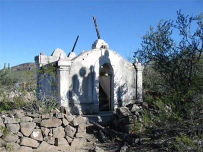
“Mission El Novillo” as shown on some maps is eighteen miles south of La Paz and three miles east of San Pedro. The chapel ruins here were part of an extensive mission cattle ranch from about 1770, but not a true mission.
“Mission Ensenada de las Palmas” located on the shore of Bahía de las Palmas near Los Barriles, but was never anything more than a Jesuit camp during the expedition to establish the Santiago mission in 1721. No ruins of any kind have ever been reported here.
“Mission La Pasión” was indeed a mission, but it was the final location for Mission Dolores. Dolores was moved from near the gulf coast in 1741 some fifteen miles southwest to what was a visita station called La Pasión by the Jesuits and called Chillá or Tañuetía by the Indians. Ruins have vanished into piles of rubble and are located just over two miles east of Rancho La Presa (now a guest ranch) which is marketing itself as the Dolores mission site. There are interesting aqueduct ruins and the grave of one of Baja’s first governors at La Presa, the ranch he founded. Fernando de la Toba was acting governor of Baja California in 1821 and he declared Baja California independent of Spain.
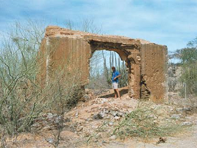
“Mission La Presentación” located eleven miles south of Mission San Javier, was a visita chapel attributed to the Franciscan’s brief time on the peninsula, built probably in 1769. Arthur North in 1906 believed the ruins were the first site for San Javier (which were actually five miles north of the final San Javier location).
“Mission San Miguel” (de Comondú) was in reality a very important visita of Mission San Javier until 1737 and after that of Mission San José de Comondú, which moved that year to just two miles from San Miguel. Several Jesuits trained at San Miguel and did perform baptisms, but a separate mission it was not.
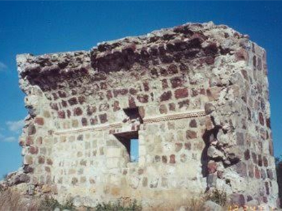
“Mission San Juan Londó” is shown twenty miles north of Loreto on some maps. Londó was indeed an important visita of Loreto and even called a mission by some Jesuits in their reports. A wall still stands of the ruined chapel just a short distance from Highway One.
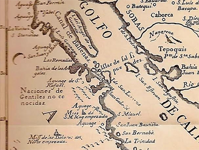
“Mission San Juan Bautista” as shown on the 1757 map is west of San Ignacio and not the Ligüí mission with the same name located south of Loreto. This proposed mission is the source of one of Baja’s famous lost mission myths, the Lost Santa Clara Mission. Located just north of Punta Abreojos are the strange-looking Santa Clara mountains. Thanks to the Jesuit map makers, treasure hunters have searched in vain to find the hidden gold and pearls the missionaries supposedly hid when they got advance word of their impending forced removal from California.
“Mission Santa María Magdalena” is shown a few miles northwest of Mulegé on some maps dating back to Arthur North’s expedition of 1905-1906 when he camped by the ruins (he was told by locals) were called La Magdalena. North read the Jesuit documents available to him and learned of a proposed mission to be called Santa María Magdalena in the north. Not thinking there could be more than one Magdalena, he applied that mission name to the ruins near Mulegé and many books and maps continued that error.
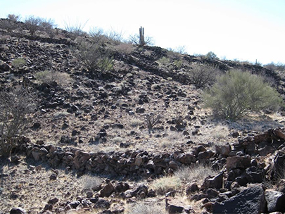
In 1966, the Erle Stanley Gardner expedition opened a route south from Bahía de los Angeles and discovered strange walls on a hillside overlooking a bay and a palm tree indicating fresh water was close to the surface. Historian-author Choral Pepper believed they had found the true Santa María Magdalena site as the location was much closer to where the Jesuits showed it on their 1757 map. However, it was a mission project that was started and never completed.
“Mission Dolores del Norte” actually did get built but not where any of the modern maps or books have shown it: northwest of San Ignacio. The Jesuits had proposed a future mission to be called Dolores del Norte beginning in reports of the 1740s. San Ignacio’s Padre Fernando Consag was even baptizing natives he met on expeditions to the north and assigning them to the future mission of Dolores. However, once the funding was obtained, a location found, and a priest was available, the mission name was changed to Santa Gertrudis. This was to honor the benefactor, the Marqués de Villapuente, whose wife was Gertrudis de la Peña.
Dolores del Norte, as a mission, only existed on paper. The extensive adobe ruins in San Pablo canyon have been called Dolores del Norte, but this was a visita site. The inhabitants of San Francisco de la Sierra also believed the walls in their mountain-top village were part of a Dolores mission, This was told Choral Pepper in the early 1960s upon her arrival there by helicopter with the Erle Stanley Gardner expedition.
“Lost Mission of Santa Isabel” is undoubtable the most famous “lost” Baja mission. Unlike the others, no map shows it (otherwise it would not be lost). The legend is born from the expulsion of the Jesuits who in California had nearly an autonomous territory under their control. Their detractors in Spain spread rumors that angered the king so much that he had them all returned to Spain as prisoners. The legend says that the Jesuits were alerted to their pending expulsion and they had time to establish one last mission in a hidden canyon in which to store their collected treasures until such time as they could return to California. Most who have searched for this mission have done so between the final Jesuit mission of Santa María and the lone desert peak of Cerro Matomí (west of Puertecitos). To read more on one of the recent Santa Isabel search parties, visit the: Lost Mission of Santa Isabel page.
About David
David Kier is a veteran Baja traveler, author of 'Baja California - Land Of Missions' and co-author of 'The Old Missions of Baja and Alta California 1697-1834'. Visit the Old Missions website.


