 |
By David Kier
With paved roads, people today can “time-travel” back when the Spanish only had a rocky path known as El Camino Real. What once took weeks or months can today take just hours to days hopping from mission to mission. Time has erased many of the structures down to just stumps of adobe or piles of rocks in many places. A few complete stone mission churches are a great reward to view while other missions are totally gone with modern buildings on the site or nothing at all.
When viewing the locations that are in ruins or vanished, try to visualize that they were once Spanish colonies with shops, homes, barracks, farms, aqueducts, and stables. The locations were always at sources of water and usually where Native Californians were already living in great numbers. Some of the mission locations are not inhabited today but most are in towns and villages that grew from the mission.
Missions were a system used by Spain to occupy a region and teach the local population about the Spanish way of living. Sadly, diseases introduced by Europeans (sailors, craftsmen, and soldiers) resulted in massive losses of the Native population. By 1840, the Indian population was so reduced that most of the missions had closed. Spain was out of the picture since 1822, following the end of the war for Independence by Mexico.
Let’s hop into our “time machines” and drive down the trans-peninsular highway, Mexico #1, to see the sites. Going south, the kilometer markers increase, from zero at the border. They reset to zero again at Ensenada, San Quintín, the L.A. Bay Highway, and at the Eagle Monument/ State Border near Guerrero Negro.
South from the Eagle Monument (state border), near Guerrero Negro, the kilometers on the markers get smaller and go to zero at Santa Rosalía, and again at Loreto, Ciudad Insurgentes, La Paz, and Cabo San Lucas.
As mentioned in Part 1, Mission Santa Gertrudis (1752) is in the northern state of Baja California but is closest to Highway One in Baja California Sur. Two graded dirt roads go to this mission. The first, at Km. 189, goes through the ghost town of El Arco and is 47 miles long. The other is ten miles shorter, begins at Km. 154.5, and goes through the ghost town of Guillermo Prieto. It joins with the El Arco road 11 miles west of the mission. Such long distance unpaved roads should only be driven in a mechanically sound SUV or 4WD truck.

San Ignacio (1728) is one of the most beautiful missions in Baja, located in a tropical date-palm oasis where a river surfaces for two miles then goes back under the lava-covered desert. Turn off the highway at Km. 73 on the paved road into the old town center, 1.6 miles. The mission faces the town plaza. Park and enjoy walking around and inside.
Guadalupe mission (1720) is located high in the backcountry 40 miles from Mulegé, at Km. 135.5. An SUV or 4WD truck is recommended for this road. Some cattle gates are passed through (reclose after passing). The mission ruins are only walls and stairs, but extensive. Access is north of the Ex-Misión de Guadalupe sign, just after the Rancho La Presa sign, through a gate on the left.
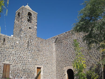
Mulegé mission (1705) is across the river just east of the highway bridge. South of the bridge a paved road turns off to the left at Km. 134 and goes east to the mission in 0.6 mile. This church was completed by the Jesuits in 1766, sixty-one years after they founded this mission, which was officially named Santa Rosalía de Mulegé. A walk behind the mission and up some stairs to a viewpoint is most rewarding.
The La Purísima (1720) mission church is gone but the area where a pair of large tombs were, next to the church, has been preserved and called the mission site. A 37-mile-long graded road goes west from Highway One at Km. 59 although it may be very rough and slow going. An option is coming in 71 miles from the south at Ciudad Insurgentes, on the all-paved Highway 53.
San José de Comondú mission is reached by a 23-mile-long graded road southeast from La Purísima or a paved road that goes south 25 miles to join Highway 53, forty miles north of Ciudad Insurgentes. A 26-mile dirt road, with some 4WD sections, connects San José de Comondú with the Loreto-San Javier highway, see below. The Comondú mission was first located 22 miles north in 1708 and moved here in 1736. The mission church building was the largest in all the Californias. By the 1900s, it was in such bad condition and was torn down in 1936 for safety reasons. A side chapel was preserved and is what is today identified as the mission.
While not a full-mission, San Juan Londó (1699) was a very important visita attached first to Mission Loreto then later to Mission Comondú. A visita was a satellite mission station that the padre would visit on rotation. This stone visita church ruin is just 0.4 mile west of Highway One at Km. 30.
Loreto was founded in 1697 and is the mother of all the California missions. From here, missions expanded out on what was believed to be an island. Twenty-seven missions would be founded on the peninsula of California over a period of 137 years. Take the main street into Loreto off Highway One at Km. 0. A pedestrian only street fronts the mission church and museum.
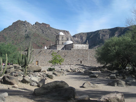
Just south of Loreto, the paved road up to San Javier turns west at Km. 117. San Javier is one mission that shouldn’t be missed, 21 miles from Highway One. Perhaps it is the best example of Jesuit-period construction on the peninsula. Founded five miles north in 1699 and moved in 1710, the stone church was constructed between 1744 and 1758. At Km. 27.5, a road (recommended for 4WD vehicles), goes west 26 miles to Mission San José de Comondú.
Ligüí was California’s third mission, founded in 1705 but abandoned in 1721. The small church foundation ruins were partially washed away after Highway One was built in the early 1970s. Somehow, the arroyo’s flow path was altered, and the mission was in its direct path. The last bit of foundation visible washed away in 2001. The village nearby erected a monument to the mission. However, by 2012 it was being washed away from flash floods and in 2017 the whole site was washed away. To see where this mission was, go east from the highway at Km. 84 on the road to the beach, Playa Ligüí. One half mile from the highway, along the road, is where the mission was, now a sandy arroyo.
Eight miles south of Ciudad Constitución at Km. 195 is the graded road east going 22 miles to Mission San Luis Gonzaga. The road is relatively easy by Baja standards, but any back country driving should be done in a good running SUV or truck, with good tires. In 1737, San Luis Gonzaga was the last mission in southern Baja California to be founded. The location had been a visita (visiting station) of the Dolores mission before being elevated to mission status with its own missionary and a separate financial benefactor. The stone church was built between 1753 and 1758. The mission was closed by the Spanish government in 1768. The two locations for the 1721 mission of Dolores (Apaté and Chillá/ La Pasión) can be reached by continuing on east. A 4WD vehicle is advised for that backcountry road. Details of the road are at: A Baja Sur Mission Adventure.
The exact location for the mission that was at La Paz from 1720 to 1748 is unknown and probably built over in the city. It was not far from the coast, at a spring, according to the letters written by the Jesuits. A plaque marking the mission, on a small side street, is not located correctly. The modern church of La Paz is often called the mission, but it was not.
South of La Paz were three missions plus the final location for the moved La Paz mission. On Highway 19, near Todos Santos at Km. 49.5, is a playground and a modern church on the east side of the highway. This was the location of the Visita de Todos Santos (1724-1733). In 1733, it became the mission of Santa Rosa, which lasted to 1748 at which time the older mission of La Paz moved here replacing it. In 1825, the mission moved one more time (to Km. 51, now the center of Todos Santos). The mission was generally called ‘Todos Santos’ after the move.
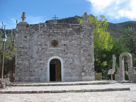
On Highway One, turn west at Km. 84.5 to see the site of Mission Santiago, moved here in 1736. Drive 1.9 miles from Highway One into the second section of the town of Santiago. A modern church is built on the mission site. A mission bell is on display inside the church.
The southernmost California mission is San José del Cabo, founded in 1730 and now in the middle of the city of the same name. Go east from Km. 32 for four blocks, then south for three blocks, and finally one more block east to the plaza. A modern church is on the final site of this mission, facing the plaza. Over the church doorway, the martyrdom of Padre Tamaral by the rebellious Pericú is illustrated.
About David
David Kier is a veteran Baja traveler, author of 'Baja California - Land Of Missions' and co-author of 'The Old Missions of Baja and Alta California 1697-1834'. Visit the Old Missions website.


