 |
By David Kier
With paved roads, people today can “time-travel” back when the Spanish only had a rocky path known as El Camino Real. What once took weeks or months can today take just hours to days hopping from mission to mission. Time has erased many of the structures down to just stumps of adobe or piles of rocks in many places. A few complete stone mission churches are a great reward to view while other missions are totally gone with modern buildings on the site or nothing at all.
When viewing the locations that are in ruins or vanished, try to visualize that they were once Spanish colonies with shops, homes, barracks, farms, aqueducts, and stables. The locations were always at sources of water and usually where Native Californians were already living in great numbers. Some of the mission locations are not inhabited today but most are in towns and villages that grew from the mission.
Missions were a system used by Spain to occupy a region and teach the local population about the Spanish way of living. Sadly, diseases introduced by Europeans (sailors, craftsmen, and soldiers) resulted in massive losses of the Native population. By 1840, the Indian population was so reduced that most of the missions had closed. Spain was out of the picture since 1822, following the end of the war for Independence by Mexico.
Let’s hop into our “time machines” and drive down the trans-peninsular highway, Mexico #1, to see the sites. Going south, the kilometer markers increase, from zero at the border. They reset to zero again at Ensenada, San Quintín, the L.A. Bay Highway, and at the Eagle Monument/ State Border near Guerrero Negro.
Mission El Descanso was established in 1830 by the Dominican Padre Félix Caballero near where Mission San Miguel had moved in 1810, following devastating floods. Today, a steel awning protects some of the unearthed foundations located next to a modern church. South of Rosarito Beach, use the older free road and turn east at Km. 49, going under the toll highway. The church is just 0.5 mile away and the mission is behind the church.
Mission San Miguel was founded in 1787 and moved the following year to this site at Km. 65.5, now in the schoolyard at La Misión. Some walls of the mission have been coated with plaster to prevent any further loss. In 1809, a flood destroyed the fields and forced the mission to be moved to El Descanso for a few years. It did return, but that year is unknown. After the return, both San Miguel and El Descanso seem to have operated together until 1834 when they were abandoned. Mission operations were transferred east to Guadalupe.
Northern missions that are not near Highway One are Guadalupe del Norte (1834), Santa Catalina (1797), and San Pedro Mártir (1794). The first two are off of Highway Three (Km. 77 north and Km. 91 east from Ensenada). The third can only be reached on foot or horseback, over 5,000 feet in the mountain range named after the mission.
Continue south from Ensenada:
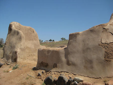
Mission Santo Tomás is nearly vanished as it has had no restoration or protection. It was first established in 1791 down the valley about three miles to the west. The mission project moved a mile east in 1794 and then to the final location in 1799. At Km. 50, in the town of Santo Tomás, is the El Palomar campground, on the east side of the highway. Ask to pass through the security gate to see the campground. Drive to the crossroad, turn left, and go outside the tree area, to see the adobe stumps from the mission period.
Mission San Vicente Ferrer (1780) has been preserved into a park with pathways to all the building ruins. They are coated in plaster to preserve what is left. The location is 0.6 mile west of the highway at Km. 88.5. This is a mile north of the town of San Vicente. A small museum is on the mission site and donations are appreciated. The Mi Ranchita restaurant is at the turnoff by Highway One, and it is excellent.
Mission Santo Domingo (1775) is 4.6 miles east of the highway, just south of Km. 169. The road is graded for all vehicles but can be rough driving. The bridge over the Santo Domingo river and the town of Colonia V. Guerrero is just past the turnoff. Santo Domingo has had its walls preserved with plaster and walkways installed to allow viewing of the complex.
El Rosario was the location of the first Baja California mission founded by the Dominican Order. It has two mission sites. The two sites are known as Arriba (Upper) and Abajo (Lower). Both have had preservation and walkways installed. The Abajo site was established in 1802, after the spring stopped flowing at the Arriba site. It is reached by turning west at Km. 57.5 where the highway makes a sharp turn to the east (just past Mama Espinoza’s restaurant). The mission is 2.0 miles away and across the river in the sister town of El Rosario de Abajo. The Arriba site, founded in 1774, is just uphill from the highway at Km. 58.5 and is located on a concrete street. There is no off-street parking, but traffic is not a problem.
San Fernando de Velicatá (1769) was the only mission in Baja California founded by the Junípero Serra of the Franciscan Order. It is 2.3 miles from Km. 121 on a fair dirt road. Sadly, a locked gate was installed in 2018 about halfway to the mission. The use of a guide with the key will be required. Contact Ed Lusk at Baja’s Best Bed & Breakfast, in El Rosario (Km. 60.5) to arrange for access. Petroglyphs are on a cliff, 0.5 mile past the mission. The large mission pila (reservoir) is just beyond the cliff.
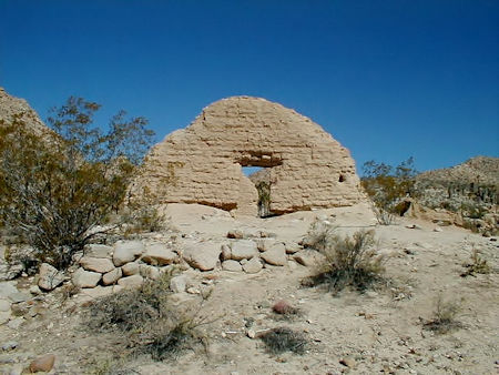
Santa María de los Ángeles is 14.5 miles from Rancho Santa Ynez, just off of Highway One at Km. 180.5 (south of Cataviña). The road to the mission is passable only to “extreme” 4WD vehicles and is considered a test to both driver and equipment. Plan on taking up to three hours for the drive and do travel with another vehicle as you are a long way from help. This was the final Jesuit mission in California, established here in 1767 after first operating at Calamajué. The impressive adobe ruins were built in 1768 by the Franciscans who replaced the Jesuits in California.
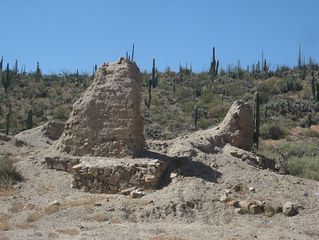
Calamajué (1766) was the first mission site for what would later become Mission Santa María. The mission here only existed for seven months before it was moved. The year-round stream killed the crops as it was too highly mineralized. Only the outlines of the adobe buildings remain and are on a terrace on the opposite side of the streambed from where the road going north climbs out of the arroyo. This road is for 4WD vehicles and it leaves Highway One at Km. 251 and goes 14 miles north to the mission. Several miles are driven in a running stream. This canyon part was also El Camino Real, the mission road. Coco’s Corner is 13.6 miles north of the mission, right off of Highway Five, between Gonzaga Bay and Laguna Chapala.
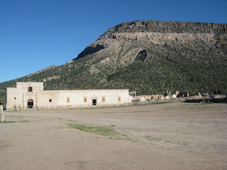
San Borja (1762) is the furthest north mission built with stone and it is intact. The earlier church adobe ruins are behind the stone church and partially protected with a steel awning. This is a must-see mission if you can drive either of the two 22-mile, dirt roads in. One road goes south to the mission from the L.A. Bay highway at Km. 45 and is usually the better of the two. The other road goes east from Highway One in the town of Nuevo Rosarito at Km. 52. Camping facilities at the mission include palapas, flush-toilets, and showers. A truck, van, or SUV is suggested for these roads.
One more mission is in the northern state of Baja California but is closest to Highway One in Baja California Sur. Santa Gertrudis (1752) is a stone mission church 47 miles from Km. 189, or 37 miles from Km. 154.5, southbound from Guerrero Negro. Both roads are dirt and an SUV or 4WD truck is recommended.
Click here to read Directions to the Missions: Part 2 - Baja Sur.
About David
David Kier is a veteran Baja traveler, author of 'Baja California - Land Of Missions' and co-author of 'The Old Missions of Baja and Alta California 1697-1834'. Visit the Old Missions website.

I purchased insurance through them & CHUBB for our trip to San Felipe. Unfortunately, we had to...

Team were on point, provided inside information, prices were great and they had my proposal already...

Great insurance for your motor trip to Mexico.