 |
By David Kier
Water sources in the desert are more valuable than gold when one is thirsty. In the not too distant past, traveling the Baja California peninsula was only possible if water could be found at intervals that were reachable before one succumbs to the heat.
The Indians used these water sources, but when thirsty they were able to survive from the desert plants while away from the springs. With the arrival of the Spanish missionaries and soldiers came horses, burros, and mules. Later came cattle as well as other animals. Good sources of water needed to be found for them and the agriculture that the missionaries created.
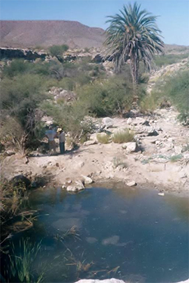
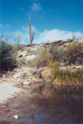
Water sources needed to be close enough to each other to be reached in a day’s travel, and the Camino Real mission road went from water source to water source between the missions. Agua Dulce (“Sweet Water”) was an excellent spring that forms a large pool of water in a most dry and barren desert. It is located midway between the missions of Santa María and San Fernando. All who traveled Baja California benefited from it. Its water was even used for building Highway One, back in 1973!
The first European discovery of Agua Dulce was made by Jesuit Padre Wenceslaus Linck on March 3, 1766, during his expedition north from Mission San Borja. He was seeking a route to the Colorado River and Sonora in order to link up with Jesuit missions over there. The spring was known to the Indians as Keita. Padre Linck writes that it had the best water they had tasted since leaving San Borja. Two days later, Linck would arrive at Valicatá and develop it as a future mission site. The Jesuits were removed from California before they could build a mission there. Velicatá did become Franciscan Padre Junípero Serra’s first California mission site, and he named it San Fernando.
Agua Dulce appears to have been named by Father Serra, as seen in his diary of 1769. It was on the new section of El Camino Real, opened by the Franciscan missionaries traveling to Alta California. In 1773, the Dominicans replaced the Franciscans in Baja California. They established 9 new missions to the north as well as maintained the existing missions on the peninsula (as long as they remained open).
Agua Dulce continued in importance as a reliable source of water through the gold rush years and then the cattle ranch years. Arthur North camped at Agua Dulce in February, 1906 and wrote about it in his 1910 ‘Camp and Camino in Lower California’. The spring and pond are in a gully, on the arroyo of Agua Dulce. The bottom of the gully is fed year-round by the water table at that level.
When the first automobile road was opened, it followed the Camino Real in northern Baja California where the terrain permitted. It came within ¼ mile of the historic spring, passing just west of it. In 1966, my family camped by the spring as an ideal site for the night during our Jeep trip to the tip. Ranchers arrived and visited with us and I remember them playing guitars and singing songs.
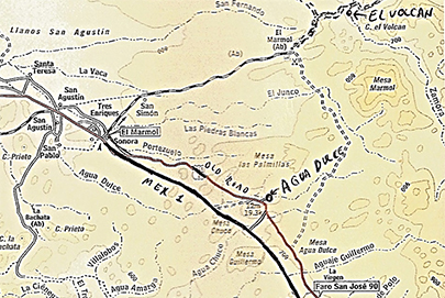
We again came to Agua Dulce in the summer of 1973 when the new trans-peninsular highway was under construction. A construction water truck road was made from the highway roadbed (near today’s Km. 157), went 1.6 miles to the old main road, 0.6 mile from of the Agua Dulce entrance road, and it was 0.3 mile more to the spring. That road was bulldozed right to the edge of the spring, destroying the natural beauty it once had.
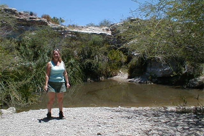
In 2002, I returned to Agua Dulce using the 1973 water truck road from Highway One and found it was badly washed out in two places. The spring was beautiful once again as nature had nearly erased the damage done in 1973. A better access road now exists and leaves the highway between just south of Km. 160. It goes 1.4 miles to the old main trans-peninsular road, then make a turn left for 0.3 mile to the Agua Dulce road. The spring is another 0.3 mile east. This is how we last visited the spring in July, 2005. A ranch has recently been established by the spring and the access road might now be gated.
Agua Dulce is a truly historic site on the California mission trail. Hopefully, the new ranch will welcome visitors to share the site. Otherwise, Google Earth is an option to see the spring: 29º52.980’, -114º49.425’ (elev. 2,312’).
About David
David Kier is a veteran Baja traveler and the co-author of 'The Old Missions of Baja and Alta California 1697-1834. Visit The Old Missions website.

