 |
An Adventure East Of Cataviña
Article and photos by David Kier
One of Baja's most rugged roads is the four wheel drive trail to the oasis mission of Santa María de los Angeles. The beauty and remoteness of this region has lured many to return many times despite the likely occurrence of vehicle damage or personal injury. One author has called Santa María: 'Mission Impossible', as it indeed is nearly impossible to get to!
The question arises as to why would the Padres build a mission in such a remote, inaccessible place? The far easier to reach site at Calamajué had abundant water. Alas, it was found unusable being too full of minerals. Nothing would grow from it, and a new site was needed.
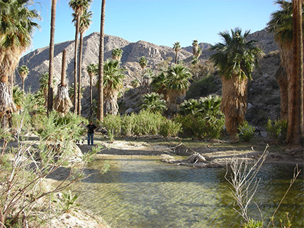
The Cochimí Indians showed the Jesuit Padre Victorianio Arnés a place they called Cabujakaamung. The new site had sweet water in a grove of palm trees, and the fine bay of San Luis Gonzaga was just down the mountain. Calamajué was nearly 30 miles distant, but there just was no other source of good water with some land to plant crops. The Calamajué mission was moved in May of 1767, and given a new name for a new beginning.
The Jesuits were only at Santa María for seven months when orders from the king of Spain expelled them from the New World, and sent them all back to Europe. Not until April of 1768, did the Franciscan Padres arrive on the California peninsula to assume control of the mission system (started 71 years earlier by the Jesuits).
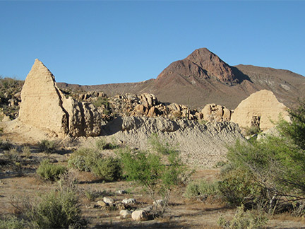
The adobe ruins at Santa María were built during the next several months, under Franciscan direction. The new Franciscan mission of San Fernando de Velicatá (founded in 1769) was just 40 miles distant and so much more promising to develop. Santa María remained open for five more years before being abandoned and its neophytes were transferred to San Fernando.
Santa Maria would slowly crumble once the palm leaf roof vanished. The ruins at Santa María fared much better than the other adobe missions to the north, due to the dryer weather and difficulty to reach by treasure hunters. Yet, treasure hunting has damaged even remote Mission Santa María.
Arthur North who traversed Baja California via mule in the early 1900's told an intriguing story about Santa Maria. In his book 'Camp and Camino in Lower California', he tells of an American who arrived at Santa Maria in 1893, with a secret agenda. The stranger dropped a cord from the old mission's ridgepole, made a mark three-foot above ground, and then disappeared. The next morning, after he had made a hurried departure from the area, natives noticed a newly excavated hole in the wall.
Walt Wheelock, a more contemporary Baja explorer, tells another version of this tale related to him by a hunting guide from San Quintin who, as a boy, had worked as a guide for Arthur North. According to this story, an Indian took an Ensenada businessman to the mission. After sighting along the ridgepole of the secondary building, adjacent to the chapel, the merchant measured two yards from the corner. He dug a hole, and retrieved a metal box containing $40,000 in placer gold and pearls. After receiving a share of the treasure, the Indian promptly drank himself to death.
The stories of treasures, lost missions, and hidden booty are likely nothing more than fantasy. The damage done to missions by treasure hunters is a real shame. The treasure really is seeing the works of the Padres and their neophyte laborers done so long ago, in a land so remote and rugged.
The next people to work hard for Santa María were the folks of Rancho Santa Ynez, a mile south of Cataviña. In the 1950's, ranch foreman Fred Hampe began to build a road from Santa Ynez to the mission, and then on to the gulf coast at Punta Final. By the 1970's they reached a point two miles beyond the mission at the edge of a big canyon down which the Santa María arroyo flows to Gonzaga Bay. That is where the road building effort was abandoned. The 1973 paving of Highway One in central Baja ended the need for a short cut through a most difficult territory.
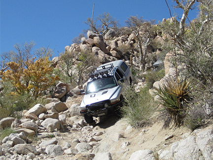
The Fred Hampe road has since become a real Baja adventure and four wheel
drive 'proving ground'. The distance to Santa María from Santa Ynez is 14.5 miles,
but even in a well equipped four wheeler one can expect to take close to 3 hours
for the drive. Large rocks, very steep grades,
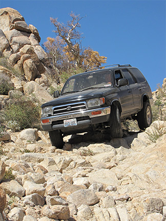 deep water and mud bogs, even
palm tree logs are all in the mix on this road. Large tires, extra ground clearance,
limited slip or locking differentials are all advised. Going in alone is not a good
idea, so find others who want to test their vehicle and driving skill against some of
the toughest road that Baja has to offer.
deep water and mud bogs, even
palm tree logs are all in the mix on this road. Large tires, extra ground clearance,
limited slip or locking differentials are all advised. Going in alone is not a good
idea, so find others who want to test their vehicle and driving skill against some of
the toughest road that Baja has to offer.
Begin in front of Rancho Santa Ynez, go around the north side of the compound to the back of the ranch. The road continues east then and crosses a big sandy arroyo. Beyond the other side of the arroyo is a fork, go left and climb up a long hill. At 1.8 miles from Santa Ynez will be your first four wheel drive (Low Range), deep arroyo crossing. If you are comfortable after this, then you passed the first test. Compared to what's ahead, it really isn't that bad, but is a good obstacle placed not far from the ranch that screens out many from getting into deep trouble!
The road is fairly easy for the next 8 miles, crossing beautiful granite country and a few palms along the way. Boojum trees and other Baja desert species are all over, to decorate the landscape. At 9.9 miles you will have reached the peninsular divide with a spectacular view of Punta Final on the Sea of Cortez. From this point the road drops down, down, down and your concern will be if you can make it back up! As you drop down from the divide, notice a trail leading off to your left towards the east. This is the cargo trail to Gonzaga Bay built for Padre Serra to bring supplies to his new mission of San Fernando. It was shorter route than using the Camino Real via Santa María, from the bay. The Padres had a warehouse on the bay (midway between Papa Fernandez' and Alfonsina's camps, the foundation can still be seen).
The road from the summit to the mission is over 'El Camino Real', the mission road and the route through California before automobiles. Mules or burros might have been a wiser choice than the four wheel drive you would use. 13.3 miles from Santa Ynez is the top of the 'widowmaker', which is one super-steep grade that drops you to the first palm oasis. The loose, big rocks and steepness will be the challenge on the return (going up) stage. Some people park their rigs here and walk the last (1.2) mile to the mission.
From the bottom of the 'widowmaker' you will soon enter the palm grove and if it has been a wet winter, you will drive in the water filled bog with water holes up to 3 feet deep. It will be time again for your locker(s) or traction control system to be on. Once you commit to the bog, just move steadily between the tall palm tree trunks, until you drive out of the water (2010 was a very wet year, 2003 a distant second). Other trips, it was mostly dry (1999, and 2007). Next, you will drive out of the bog and over a rocky ridge to the valley containing the mission. This final half mile has some very steep, short drops. Two of us on the last trip severely bent our back bumpers, on a steep drop.
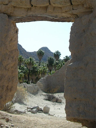
Drive up to the plateau the mission is built upon, and at 14.5 miles and you made it! The main church was the primary structure and to the side, in the back corner was a two room building that is nearly melted all the way down. The side walls of the mission are mostly gone. The front and back faces of the church still standing tall. The doorway is on the east face and the altar was on the opposite west end. Irrigation canals were just below the mission. Not far up the west hill is a large stone corral and other livestock pens.
Driving past the mission the road makes two steep drops and enters the sandy arroyo, 1 mile from the mission. Camping can be down in the palms to the west at a large pool, or head further down the big arroyo. Tracks end in a palm grove near the rocky drop into the canyon. However, at Mile 1.3 from the mission, look for a pair of small cardon cactus to the left (north), above the arroyo. These cactus mark were the bulldozed road leaves the arroyo to climb up the canyon ridge, the road was hidden by a low palm tree. A half mile from the arroyo, the California El Camino Real climbs up from this road at the base of the hill, switch-backing to the top and then following the canyon's north rim to where it reaches the desert floor. At the end of the bulldozed road is a view into the canyon, petroglyphs on rocks, and an Indian trial that leads down into the canyon. This was the first El Camino Real route, but it was so dangerous in the canyon, a new trail was made staying in the hills above the canyon.
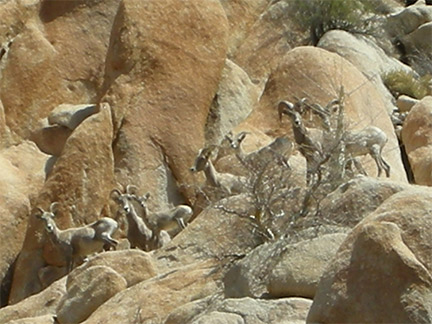
Lions, Bighorns, coyotes, rattlesnakes all live here so keep your eyes open and watch your step...you're not in Kansas anymore!

Easy, fast, and affordable.

Good quality, affordable, and easily accessible insurance for Mexico!

Great service, whoever answered my call was very helpful. First time using Baja Bound and I was...