 |
By David Kier
The Jesuits had begun the colonization process in California, a land many considered to be an island. Missions were founded at Loreto, San Javier, Ligüí, Mulegé, and Comondú between 1697 and 1708. The need for supplies from Mexico, across the gulf, were greater than ever. Until the missions could become fully sustainable agricultural centers, food and equipment had to come across the sometimes-treacherous Gulf of California.
The ships available to the missionaries were hardly sea worthy and many never reached the opposite shore or navigation took many times longer and supplies often arrived spoiled. The leading Jesuit in California at the time was Juan de Ugarte, he was in charge at San Javier and quite the force in keeping the five missions operating. The Jesuits would obtain ships in Mexico and then they would sink. A good ship was going to be the most important tool to continue the California mission program. Padre Ugarte was determined to have one built to the highest standards and was seeking sources of lumber in Mexico when his Indian neophytes told him a great stand of tall trees in the mountains west of Mulegé. In September 1719, Ugarte, with the shipbuilder, soldiers, and Indians investigated. The güéribo trees (a type of poplar) grow tall and straight and would make fine timbers for Ugarte’s ship. Trees were chopped and oxen used to bring the logs to Mulegé where the ship was built.
English shipbuilder William Strafford oversaw the construction and on September 14, 1720, the ship that Padre Ugarte named El Triunfo de la Cruz, was launched. In November, the ship was used by Ugarte and Padre Jaime Bravo to establish a mission at La Paz. The next year, El Triunfo de la Cruz sailed to the Colorado Delta to prove to Ugarte that California was not an island. This fact had been proven in 1539, 1540, and 1700, but the romantic notion that California was an island would continue for decades.
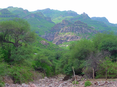
The land where the güéribo trees were cut was known as Huasinapí and the Cochimí Indians asked if they could have their own mission. German Jesuit, Padre Everaldo Hellen had recently learned the Cochimí language and was sent into the mountains to establish the eighth California mission. Founded on December 26, 1720, Nuestra Señora de Guadalupe de Huasinapí, began in a most rugged and remote mountain valley. There was no land for crops beyond small garden plots. The raising of goats was the greatest success here. Padre Helen reached out to Indians all over these mountains and converted 1,707 to Christianity by 1726.
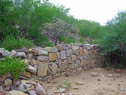
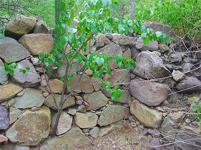
A 1744 report by the Jesuit Visitador General, Juan Antonio Baltasar, said Mission Guadalupe had “the finest church in California.” Shortly after Baltasar’s visit, a storm had blown over the church wall and killed 100 neophytes seeking shelter inside. The adobe walls were replaced with more stone for support in 1750.
The population declined to 544 when the Franciscans replaced the Jesuits here in 1768. In just five more years, the Dominicans replaced the Franciscans in Baja California and the Guadalupe population was down to just 169. In 1795, the mission was closed and the remaining 74 native Indians were moved to La Purísima. If not for the many letters and reports made by the missionaries, this remote mission may have easily been lost to time. Mainland Mexicans came to Baja California in the mid-1800s, as well as Spanish soldiers who stayed on the peninsula after 1822, would begin to farm and ranch the former mission lands.
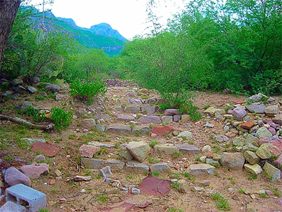
Until about 25 years ago, you had to ride a mule for several hours to see Mission Guadalupe. Located on California’s El Camino Real, between Loreto and San Ignacio, Guadalupe is in one very rugged valley. The government bulldozed a road to it from San José de Magdalena but the hurricanes of recent years totally wiped away that road. The option below is passable, but not for those in a hurry!
MULEGE TO MISSION GUADALUPE, 40.5 miles, 4 hours.
ROAD LOG:
Total / Partial Miles
0.0 0.0 Hwy. 1 Mulegé, Km. 135.5 Take concrete street going west, known locally as the “Ice Road” as it passes an ice plant.
1.1 / 1.1 End of pavement
2.4 / 1.3 Construction equipment yard, continue west.
2.7 / 0.3 Fork. Ahead is the original road, but rocky. Left (south) is an alternate.
5.1 / 2.4 Cattle Guard
6.0 / 0.9 The alternate road junctions in from left.
8.3 / 2.3 Rancho Trinidad junction, south (small sign). Take right fork.
11.1 / 2.8 Rancho Trinidad junction, south (big signs). Continue west.
The road enters a canyon and begins a steep climb with one concrete section of road.
24.6 / 13.5 Rancho El Aguajito
25.0 / 0.4 La Ballena Fork. Turn north for Guadalupe. Big signs. Ahead goes to San Miguel and on to the Pacific side of the peninsula.
25.8 / 0.8 Gate (always reclose behind you)
34.1 / 8.3 Fork. Go right. Left to ranch.
34.7 / 0.6 Gate.
36.9 / 2.2 Gate.
40.0 / 3.1 Road west. Once was passable to San Ignacio via Las Tunas and El Patrocinio. Inquire locally for conditions.
40.1 / 0.1 Gate.
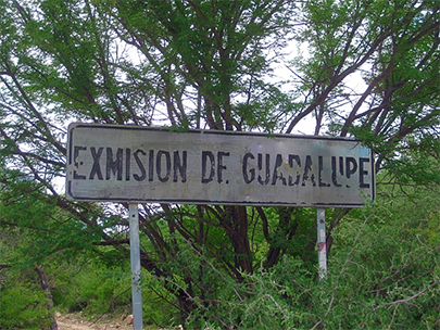
40.5 / 0.4 EX-MISION de GUADALUPE sign, turn left, cross arroyo, park near gate on the right.
The gate was wired shut, but no signs were posted. The road beyond the gate was going to have some concrete pillars along it leading to the possible museum structure at the end of the road. The project was abandoned. The mission ruins are just north and west, uphill of the cinder block building area. Take your time and make discoveries. As with all historical sites, take only photos and leave only footprints. If you are not comfortable going through the fence, seek a guide at one of the nearby ranches.
The road traveled from Mulegé continues north, past the ‘Ex-Mision’ sign. The road straight from here goes to Rancho La Presa at Mile 40.7 and ends. Before the ranch, at Mile 40.6 is a right fork that climbs a hill and is the washed-out road that once went to San José de Magdalena, not passable after 1 mile. A photo opportunity of the mission area is available just up this road.
About David
David Kier is a veteran Baja traveler and the co-author of 'The Old Missions of Baja and Alta California: 1697-1834. David Kier’s research on the twenty-seven missions of Baja California was recently published in a new comprehensive book. Visit The Old Missions website for additional information.

I have used Baja Bound for years. Very easy and affordable.

When they say above and beyond they mean do to the good roads I had 2 flat tire wit out a spare...

Our go to Baja car insurance, everytime we take a visit down south . Usually it's for a day trip...