 |
By David Kier
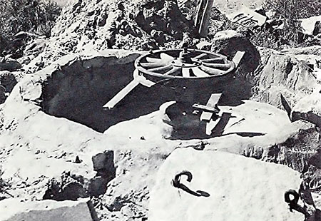
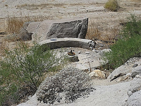
Las Arrastras de Arriola is another Baja California historic site that could soon vanish under the construction of Highway 5. This is how Howard Gulick, in the Lower California Guidebook, described it: “A wide clearing. At right in a gully is a well of good water. The place was named for the old ore mills here.” An arrastra is a round wheel stone, set in a pit over the gold ore. The wheel stone is turned by hand or animal to reduce the ore in order to extract the gold.
In 1952, while researching for the Lower California Guidebook, Howard Gulick made notes on El Camino Real, the mission road across Baja California. Gulick was able to get his Jeep to the good waterhole of San Francisquito, 0.6 mile past a camp known then as either Las Arrastras or Campo Grosso. Juan Grosso ran the camp and mills, he was born in 1894, the third of ten children. His oldest brother was Arturo Grosso who ran Rancho Laguna Chapala, a dozen miles away. Their youngest sister was the famous Mama (Anita) Grosso de Espinoza, of El Rosario.
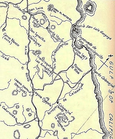
The waterhole of San Francisquito was known in earlier times as San Francisco. The Franciscan Missionary, Junípero Serra mentioned San Francisco as a stopping place between Calamajué and Santa María in May of 1769 during his trek from Loreto to San Diego. Everything in the region was connected by name with this water source on El Camino Real: the arroyo leading to the gulf (Arroyo de San Francisquito), the bay south of San Luis Gonzaga (Ensenada de San Francisquito), the gold mill near Punta Final run by William Lacy (Molino de San Francisquito), etc.
Arthur North in his 1910 book, Camp and Camino in Lower California, writes that San Francisquito consisted of a few old arrastras, a small mining shaft and a waterhole, on his visit in 1906.
In the 1961 travel adventure book, Yesterday’s Land by Leonard Wibberley, the location was deserted but a sign there said “Agua” (Water) and upon investigation he found the gold mill remains and a well. Wibberley writes the well had been drilled through eighteen feet of solid granite. A windlass and bucket was over the well and when lowered the splash was soon heard. Up came the water and it was wonderfully clean. They drank and filled their containers.
In 1967, Harry Crosby arrived at Las Arrastras by mule as he traveled north researching and photographing the mission road from Loreto to San Diego. In Crosby’s 1974 book, The King’s Highway in Baja California, Juan Grosso greeted Harry and his companion at his roadside restaurant and gasoline sales business. Crosby called Grosso “a gentile eccentric” who lived with his cook. In a cave below, facing the gully was a tiny old Indian miner named Pedro Navarez who had “alternating fits of gloom and euphoria,” according to Crosby. Juan Grosso eventually moved to El Rosario to join other relatives, but Las Arrastras would soon be the home of a family who continued to serve travelers and sell turquoise mined nearby.
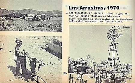
In 1977, Jim Hunter published his guide, Offbeat Baja. Hunter meets Manuel Cantrera and his children Francisco and Guadalupe. Manuel was a laborer in Tijuana but did not like the affect city life was having on his children. He mines some turquoise and other minerals to sell to tourists. Hunter tells of the shower service provided him from Francisco using the well water, below their home.
In 1979, I stopped at Las Arrastras to have a look at the colorful rocks offered for sale. The auto club guide continues to mention the location as a source for water and other services through the 1980s and 1990s. By the mid-1990s, Las Arrastras would acquire a new neighbor, four miles south. Jorge Enrique Corral, better known as ‘Coco,’ created Coco’s Corner and for over twenty years has been a popular stop for cold beer and conversation. A double amputee, Coco has been providing visitors to his Corner with local travel information ever since.
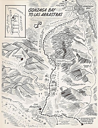
In 2014, the construction of a new paved highway pushed south from Bahía San Luis Gonzaga with an alignment that would take it west of the current road and bypass Coco’s Corner. The new route leaves the original one at Las Arrastras, and in July 2016, a road construction camp was set up at Las Arrastras. It is possible the new highway will obliterate any ruins of the mills and site of Las Arrastras. Time will tell, as it may be at least a couple more years before the road is completed.
UPDATE: In 2018, the Highway 5 alignment missed Las Arrastras by passing just west of the site. The highway was completed and open in 2020. Las Arrastras is now at Km. 179.5. In April 2021, Coco's Corner moved north to Las Arrastras so that Coco could again have visitors after the highway had bypassed his former location by several miles.
About David
David Kier is a veteran Baja traveler, author of 'Baja California - Land Of Missions' and co-author of 'The Old Missions of Baja and Alta California 1697-1834'. Visit the Old Missions website.

Thank you Baja Bound for how quick and easy it was to get car insurance coverage for our recent...

I had an awesome experience with Baja Bound. Family owned and highly personal, top notch customer...

Prior to my retirement, our family would travel to Mexico frequently. Since we would do so by car...