 |
Article and photos by David Kier
A Baja mystery is waiting to be examined by desert and history buffs, just a few miles from Highway One. Most modern maps show it as a mission, but they don't have it in the correct place. Historians disagree as to what it was and that makes it all the more interesting to visit and ponder its purpose!
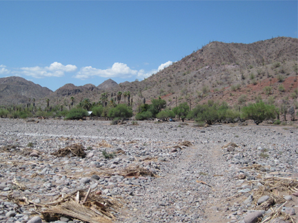
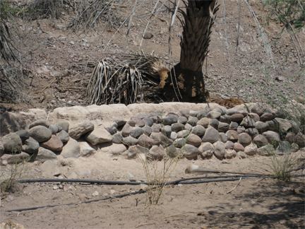
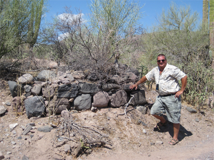
Located sixteen miles northwest of Mulege are stone ruins and a large reservoir that was fed by an aqueduct originating miles away at the oasis of San Jose de Magdalena. The dirt road does not require four wheel drive, but is best driven in a truck or SUV.
So little is recorded on the ruins of Magdalena, that even its full name is in doubt. On February 12, 1772,
Franciscan Friar Francisco Palou may have been the first to describe the site while in charge of the mission at Mulege. Fr. Palou considered moving the mission
 following floods in 1770 that severely damaged the fields and irrigation works. Palou writes: "On this account I examined a place called Magdalena, about 10 leagues from the mission on the road to San Ignacio, and I discovered it had an arroyo with sufficient water."
The Jesuits had proposed establishing a mission called Santa Maria Magdalena and it is included on a 1745 list of missions and a 1757 map where it was labeled as 'started', but far to the north and closer to Bahia de los Angeles. The Franciscans replaced the Jesuits in 1768 and no further mention was made of Santa Maria Magdalena by them or the Dominicans who took over the Baja California missions five years later.
Arthur North, in 1906, came upon the ruins and may have been the first to call them 'Santa Maria (de la) Magdalena' as they were near San Jose de Magdalena. North mentions that Baja travelers before him had mistaken the Magdalena ruins as the mission of Guadalupe (which is high in the mountains, 18 more miles west). Ever since North's two Baja books ('Mother of California' in 1908, and 'Camp and Camino in Lower California' in 1910) were published, authors and map makers have continued with the error of calling these desert ruins 'Santa Maria Magdalena'.
Marquis McDonald's 1968 'Baja: Land of Lost Missions' is one such book. McDonald traveled the peninsula by Jeep for several months in 1949 to 1950 to see every mission. McDonald described and photographed the desert Magdalena site.
Historian Peter Gerhard in the 1956 'Lower California Guidebook' co-authored with Howard Gulick, listed these ruins and irrigation works as part of a Dominican chapel from 1774. However, historian W. Michael Mathes in his 1977 mission book says a ruined stone chapel, about 5 miles west and across the arroyo from San Jose de Magdalena, is the 1774 Dominican site.
Choral Pepper in her 1973 book 'Baja California: Vanished Missions, Lost Treasures, Strange Stories Tall and True' correctly mentions Fr. Palou's plan to move Mulege to Magdalena and notes that the stone ruins there have been misidentified as Santa (Maria) Magdalena, which Pepper says is an unfinished mission on the coast to the north.
Dave Werschkul in his 2003 mission history and guide ('Saints and Demons in a Desert Wilderness') lists both Magdalena sites, calling the one in the desert 'Santa Maria Magdalena' and the one 5 miles west 'San Jose de Magdalena'. Werschkul mentions the desert site as being of Jesuit origin from 1708, built three years after the Mulege mission was founded.
Perhaps both sites were part of the same project and built by the same people? Whatever the case, it makes for an interesting Baja side trip from the highway between Santa Rosalia and Mulege.
Getting There
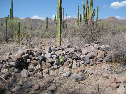
Only 4.6 dirt road miles to the ruins: Leave Highway One at a point 3.8 miles south of the signed road to San Jose de Magdalena, and just north of the series of bridges over the wide Magdalena arroyo (between Km. 162 and 163). Go west 3.7 miles from Hwy. 1, taking the left fork ¼ mile from the highway. See the road to the left (south) and take it (was signed for Rancho La Posa). Cross the wide Arroyo Boca de Magdalena towards the ranch. At this point the aqueduct along the mountainside is seen and is what brought water to the pila (reservoir) near the ruins. Turn left on the far side of the arroyo. Go 0.6 mile (passing a blue ranch house) to the many ruins which are on both side of the road, and explore. GPS at the ruins is N27º03'30' W112º10'07' (WGS84). The pila is 300 feet west of the ruins and can be seen on Internet satellite images, as well as the aqueduct leading to it.

Good seevice have use baja bound for many years good price....

Mexican Insurance made easy, I have used Baja Bound Mexican Insurance for all most 5 years, price...

Incredibly fast and painless. Paid about $180 for a month of coverage. It was easier than going on...